Štefanje geodata
Štefanje (Bjelovarsko-Bilogorska) is a seat of a second-order administrative division; located in Croatia in Europe/Zagreb (GMT+2) time zone. In our database, there are 904 cities with bigger population. Compared to other cities in Croatia, 72.2% of cities are located further ↓South; 60.6% of cities are located further ←West and 66.3% of cities have lower elevation than Štefanje. Note1


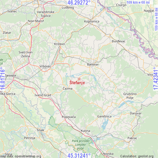
Štefanje GPS coordinates[2]
45° 48' 16.992" North, 16° 43' 13.008" East
| Map corner | latitude | longitude |
|---|---|---|
| Upper-left | 46.29272°, | 16.01716° |
| Center: | 45.80472°, | 16.72028° |
| Lower-right: | 45.31241°, | 17.42341° |
| Map W x H: | 109×109 km | = 67.7×67.7mi |
| max Lat: | 46.52694° ⇑27.8% North |
| Štefanje: | 45.80472° |
| min Lat: | ⇓72.2% South 42.54972° |
| min Long | Štefanje | max Long |
| 13.52389° | 16.72028° | 19.37694° |
| W 60.6%⇐ | ⇒39.4% E |
Elevation
Elevation of Štefanje is 157 m = 515 ft, and this is 3.7 m = 12 ft above average elevation for this country.
| Max E: |
827 m = 2713 ft | 33.7% |
| Štefanje | 157 m 515 ft | |
| Avg. | 153.3 m = 503 ft | |
Min E: |
-1 m = -3 ft | 66.3% |
See also: Croatia elevation on elevation.city.
Geographical zone
Štefanje is located in North temperate zone (between Tropic of Cancer and the Arctic Circle). Distance of this North polar circle is 2308.2 km =1434.2 mi to North.| Distance of | km | miles | from Štefanje |
|---|---|---|---|
| North Pole | 4914.1 | 3053.5 | to North |
| Arctic Circle | 2308.2 | 1434.2 | to North |
| Tropic Cancer | 2487.1 | 1545.4 | to South |
| Equator | 5093 | 3164.6 | to South |


Nearby cities:
15 places around Štefanje: (largest is in red/bold)
• Berek
11.3 km =7 mi,  130°
130°
• Bjelovar
14.4 km =8.9 mi,  43°
43°
• Brezovac
11.7 km =7.3 mi,  53°
53°
• Cirkvena
14.8 km =9.2 mi,  341°
341°
• Dubrava
14.6 km =9.1 mi,  284°
284°
• Farkaševac
10.3 km =6.4 mi,  323°
323°
• Gudovac
9.6 km =6 mi,  29°
29°
• Ivanska
7.7 km =4.8 mi,  112°
112°
• Klokočevac
13.4 km =8.3 mi,  21°
21°
• Narta
6 km =3.7 mi,  58°
58°
• Prgomelje
9.9 km =6.2 mi,  14°
14°
• Stare Plavnice
13 km =8.1 mi, 35°
• Veliko Korenovo
8 km =5 mi, 50°
• Čazma
10.4 km =6.5 mi,  232°
232°
• Ždralovi
14.4 km =8.9 mi, 56°
Sources, notices
• [Note1] Compared only with cities in Croatia existing in our database
• [Src1] Map data: © OpenStreetMap contributors (CC-BY-SA)
• [Src2] Other city data from geonames.org with taken over terms of usage.
• [Src3] Geographical zone / Annual Mean Temperature by Robert A. Rohde @ Wikipedia
