Dubrava geodata
Dubrava (Zagrebačka) is a seat of a second-order administrative division; located in Croatia in Europe/Zagreb (GMT+2) time zone. In our database, there are 904 cities with bigger population. Compared to other cities in Croatia, 73.8% of cities are located further ↓South; 53.2% of cities are located further ←West and 58.4% of cities have lower elevation than Dubrava. Note1


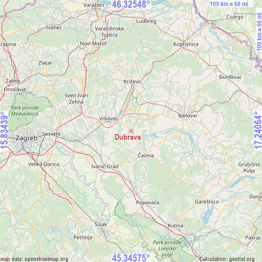
Dubrava GPS coordinates[2]
45° 50' 15.972" North, 16° 32' 15.036" East
| Map corner | latitude | longitude |
|---|---|---|
| Upper-left | 46.32548°, | 15.83439° |
| Center: | 45.83777°, | 16.53751° |
| Lower-right: | 45.34575°, | 17.24064° |
| Map W x H: | 108.9×108.9 km | = 67.7×67.7mi |
| max Lat: | 46.52694° ⇑26.2% North |
| Dubrava: | 45.83777° |
| min Lat: | ⇓73.8% South 42.54972° |
| min Long | Dubrava | max Long |
| 13.52389° | 16.53751° | 19.37694° |
| W 53.2%⇐ | ⇒46.8% E |
Elevation
Elevation of Dubrava is 141 m = 463 ft, and this is 12.3 m = 40 ft below average elevation for this country.
| Max E: |
827 m = 2713 ft | 41.6% |
| Avg. | 153.3 m = 503 ft | |
| Dubrava | 141 m = 463 ft | |
Min E: |
-1 m = -3 ft | 58.4% |
See also: Croatia elevation on elevation.city.
Geographical zone
Dubrava is located in North temperate zone (between Tropic of Cancer and the Arctic Circle). Distance of this North polar circle is 2304.5 km =1431.9 mi to North.| Distance of | km | miles | from Dubrava |
|---|---|---|---|
| North Pole | 4910.4 | 3051.2 | to North |
| Arctic Circle | 2304.5 | 1431.9 | to North |
| Tropic Cancer | 2490.8 | 1547.7 | to South |
| Equator | 5096.7 | 3166.9 | to South |


Nearby cities:
15 places around Dubrava: (largest is in red/bold)
• Brčevec
9.9 km =6.2 mi,  288°
288°
• Bunjani
15.6 km =9.7 mi,  190°
190°
• Cirkvena
14.1 km =8.8 mi,  42°
42°
• Cubinec
16.3 km =10.1 mi,  7°
7°
• Farkaševac
9.2 km =5.7 mi,  59°
59°
• Gradec
9.2 km =5.7 mi,  332°
332°
• Haganj
8.7 km =5.4 mi,  23°
23°
• Kloštar Ivanić
13.9 km =8.6 mi,  219°
219°
• Lonjica
16.2 km =10.1 mi,  276°
276°
• Lupoglav
15.5 km =9.6 mi,  252°
252°
• Pavlovec Gradečki
8.1 km =5 mi, 328°
• Sveti Ivan Žabno
13.4 km =8.3 mi,  25°
25°
• Vrbovec
10.3 km =6.4 mi,  299°
299°
• Čazma
11.6 km =7.2 mi,  149°
149°
• Štefanje
14.6 km =9.1 mi,  104°
104°
Sources, notices
• [Note1] Compared only with cities in Croatia existing in our database
• [Src1] Map data: © OpenStreetMap contributors (CC-BY-SA)
• [Src2] Other city data from geonames.org with taken over terms of usage.
• [Src3] Geographical zone / Annual Mean Temperature by Robert A. Rohde @ Wikipedia
