Čazma geodata
Čazma (Bjelovarsko-Bilogorska) is a seat of a second-order administrative division; located in Croatia in Europe/Zagreb (GMT+2) time zone. With population of 2,892 people, there are 145 cities with bigger population in this country. Compared to other cities in Croatia, 68.1% of cities are located further ↓South; 56.8% of cities are located further ←West and 56.5% of cities have lower elevation than Čazma. Note1


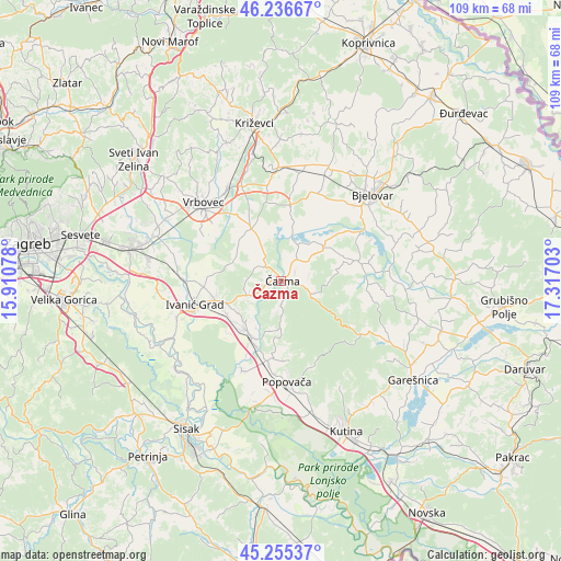
Čazma GPS coordinates[2]
45° 44' 53.448" North, 16° 36' 50.04" East
| Map corner | latitude | longitude |
|---|---|---|
| Upper-left | 46.23667°, | 15.91078° |
| Center: | 45.74818°, | 16.6139° |
| Lower-right: | 45.25537°, | 17.31703° |
| Map W x H: | 109.1×109.1 km | = 67.8×67.8mi |
| max Lat: | 46.52694° ⇑31.9% North |
| Čazma: | 45.74818° |
| min Lat: | ⇓68.1% South 42.54972° |
| min Long | Čazma | max Long |
| 13.52389° | 16.6139° | 19.37694° |
| W 56.8%⇐ | ⇒43.2% E |
Elevation
Elevation of Čazma is 138 m = 453 ft, and this is 15.3 m = 50 ft below average elevation for this country.
| Max E: |
827 m = 2713 ft | 43.5% |
| Avg. | 153.3 m = 503 ft | |
| Čazma | 138 m = 453 ft | |
Min E: |
-1 m = -3 ft | 56.5% |
See also: Croatia elevation on elevation.city.
Geographical zone
Čazma is located in North temperate zone (between Tropic of Cancer and the Arctic Circle). Distance of this North polar circle is 2314.5 km =1438.2 mi to North.| Distance of | km | miles | from Čazma |
|---|---|---|---|
| North Pole | 4920.3 | 3057.3 | to North |
| Arctic Circle | 2314.5 | 1438.2 | to North |
| Tropic Cancer | 2480.8 | 1541.5 | to South |
| Equator | 5086.7 | 3160.7 | to South |


Nearby cities:
15 places around Čazma: (largest is in red/bold)
• Berek
16.8 km =10.4 mi,  93°
93°
• Bunjani
10.3 km =6.4 mi,  238°
238°
• Deanovec
11.8 km =7.3 mi, 240°
• Dubrava
11.6 km =7.2 mi,  329°
329°
• Farkaševac
14.7 km =9.1 mi,  8°
8°
• Ivanić-Grad
17.4 km =10.8 mi,  255°
255°
• Ivanska
15.7 km =9.8 mi,  77°
77°
• Kloštar Ivanić
14.7 km =9.1 mi,  266°
266°
• Križ
11.6 km =7.2 mi,  217°
217°
• Narta
16.3 km =10.1 mi,  54°
54°
• Novoselec
12.2 km =7.6 mi,  209°
209°
• Obedišće
13.6 km =8.5 mi,  199°
199°
• Velika Ludina
16.5 km =10.3 mi,  183°
183°
• Vidrenjak
15.6 km =9.7 mi,  191°
191°
• Štefanje
10.4 km =6.5 mi, 52°
Sources, notices
• [Note1] Compared only with cities in Croatia existing in our database
• [Src1] Map data: © OpenStreetMap contributors (CC-BY-SA)
• [Src2] Other city data from geonames.org with taken over terms of usage.
• [Src3] Geographical zone / Annual Mean Temperature by Robert A. Rohde @ Wikipedia
