Šandrovac geodata
Šandrovac (Bjelovarsko-Bilogorska) is a seat of a second-order administrative division; located in Croatia in Europe/Zagreb (GMT+2) time zone. With population of 855 people, there are 554 cities with bigger population in this country. Compared to other cities in Croatia, 77.7% of cities are located further ↓South; 68.4% of cities are located further ←West and 61.4% of cities have lower elevation than Šandrovac. Note1


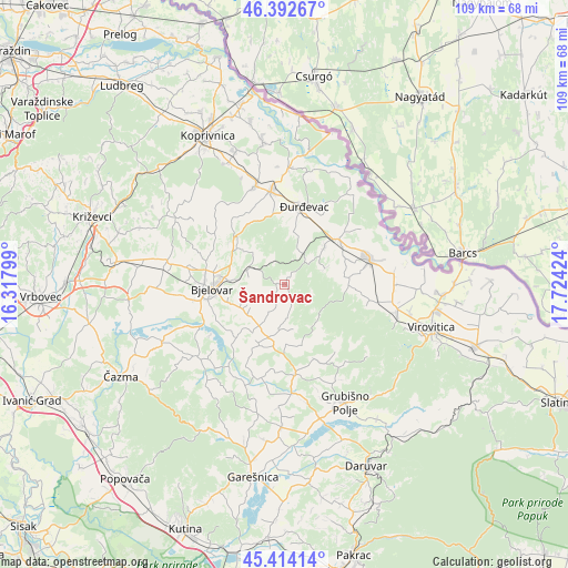
Šandrovac GPS coordinates[2]
45° 54' 20.016" North, 17° 1' 15.996" East
| Map corner | latitude | longitude |
|---|---|---|
| Upper-left | 46.39267°, | 16.31799° |
| Center: | 45.90556°, | 17.02111° |
| Lower-right: | 45.41414°, | 17.72424° |
| Map W x H: | 108.8×108.8 km | = 67.6×67.6mi |
| max Lat: | 46.52694° ⇑22.3% North |
| Šandrovac: | 45.90556° |
| min Lat: | ⇓77.7% South 42.54972° |
| min Long | Šandrovac | max Long |
| 13.52389° | 17.02111° | 19.37694° |
| W 68.4%⇐ | ⇒31.6% E |
Elevation
Elevation of Šandrovac is 147 m = 482 ft, and this is 6.3 m = 21 ft below average elevation for this country.
| Max E: |
827 m = 2713 ft | 38.6% |
| Avg. | 153.3 m = 503 ft | |
| Šandrovac | 147 m = 482 ft | |
Min E: |
-1 m = -3 ft | 61.4% |
See also: Croatia elevation on elevation.city.
Geographical zone
Šandrovac is located in North temperate zone (between Tropic of Cancer and the Arctic Circle). Distance of this North polar circle is 2297 km =1427.3 mi to North.| Distance of | km | miles | from Šandrovac |
|---|---|---|---|
| North Pole | 4902.8 | 3046.5 | to North |
| Arctic Circle | 2297 | 1427.3 | to North |
| Tropic Cancer | 2498.3 | 1552.4 | to South |
| Equator | 5104.2 | 3171.6 | to South |


Nearby cities:
15 places around Šandrovac: (largest is in red/bold)
• Bjelovar
13.3 km =8.3 mi,  266°
266°
• Budančevica
13.2 km =8.2 mi,  49°
49°
• Gornje Plavnice
12.3 km =7.6 mi,  284°
284°
• Kloštar Podravski
13.4 km =8.3 mi, 51°
• Kozarevac
7.9 km =4.9 mi,  70°
70°
• Lasovac
6 km =3.7 mi,  173°
173°
• Nova Rača
13.2 km =8.2 mi,  203°
203°
• Novoseljani
10.9 km =6.8 mi,  256°
256°
• Prespa
9.2 km =5.7 mi,  241°
241°
• Prugovac
10.5 km =6.5 mi, 46°
• Severin
9.2 km =5.7 mi,  211°
211°
• Velika Pisanica
12.1 km =7.5 mi,  163°
163°
• Velika Črešnjevica
12.4 km =7.7 mi,  89°
89°
• Veliko Trojstvo
7.5 km =4.7 mi,  296°
296°
• Ždralovi
11.8 km =7.3 mi,  253°
253°
Sources, notices
• [Note1] Compared only with cities in Croatia existing in our database
• [Src1] Map data: © OpenStreetMap contributors (CC-BY-SA)
• [Src2] Other city data from geonames.org with taken over terms of usage.
• [Src3] Geographical zone / Annual Mean Temperature by Robert A. Rohde @ Wikipedia
