Raša geodata
Raša (Istria) is a seat of a second-order administrative division; located in Croatia in Europe/Zagreb (GMT+2) time zone. With population of 1,661 people, there are 258 cities with bigger population in this country. Compared to other cities in Croatia, 73.6% of cities are located further ↑North; 96% of cities are located further →East and 69% of cities have higher elevation than Raša. Note1


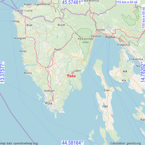
Raša GPS coordinates[2]
45° 4' 49.008" North, 14° 4' 44.004" East
| Map corner | latitude | longitude |
|---|---|---|
| Upper-left | 45.57461°, | 13.37577° |
| Center: | 45.08028°, | 14.07889° |
| Lower-right: | 44.58164°, | 14.78202° |
| Map W x H: | 110.4×110.4 km | = 68.6×68.6mi |
| max Lat: | 46.52694° ⇑73.6% North |
| Raša: | 45.08028° |
| min Lat: | ⇓26.4% South 42.54972° |
| min Long | Raša | max Long |
| 13.52389° | 14.07889° | 19.37694° |
| W 4%⇐ | ⇒96% E |
Elevation
Elevation of Raša is 96 m = 315 ft, and this is 57.3 m = 188 ft below average elevation for this country.
| Max E: |
827 m = 2713 ft | 69% |
| Avg. | 153.3 m = 503 ft | |
| Raša | 96 m = 315 ft | |
Min E: |
-1 m = -3 ft | 31% |
See also: Croatia elevation on elevation.city.
Geographical zone
Raša is located in North temperate zone (between Tropic of Cancer and the Arctic Circle). Distance of this North polar circle is 2388.7 km =1484.3 mi to North.| Distance of | km | miles | from Raša |
|---|---|---|---|
| North Pole | 4994.6 | 3103.5 | to North |
| Arctic Circle | 2388.7 | 1484.3 | to North |
| Tropic Cancer | 2406.5 | 1495.3 | to South |
| Equator | 5012.5 | 3114.6 | to South |


Nearby cities:
15 places around Raša: (largest is in red/bold)
• Barban
5.4 km =3.4 mi,  251°
251°
• Gorica
8.5 km =5.3 mi,  323°
323°
• Gračišće
16.3 km =10.1 mi,  340°
340°
• Kanfanar
19.4 km =12.1 mi,  283°
283°
• Kršan
11.4 km =7.1 mi,  24°
24°
• Labin
3.6 km =2.2 mi,  62°
62°
• Marčana
17 km =10.6 mi,  215°
215°
• Nedeščina
7.1 km =4.4 mi, 21°
• Pićan
14.3 km =8.9 mi,  348°
348°
• Potpićan
12.2 km =7.6 mi,  7°
7°
• Rabac
6.2 km =3.9 mi,  90°
90°
• Sveti Petar u Šumi
20.1 km =12.5 mi,  304°
304°
• Svetvinčenat
15.4 km =9.6 mi,  273°
273°
• Vinež
3 km =1.9 mi,  48°
48°
• Žminj
15 km =9.3 mi, 297°
Sources, notices
• [Note1] Compared only with cities in Croatia existing in our database
• [Src1] Map data: © OpenStreetMap contributors (CC-BY-SA)
• [Src2] Other city data from geonames.org with taken over terms of usage.
• [Src3] Geographical zone / Annual Mean Temperature by Robert A. Rohde @ Wikipedia
