Kanfanar geodata
Kanfanar (Istria) is a seat of a second-order administrative division; located in Croatia in Europe/Zagreb (GMT+2) time zone. With population of 535 people, there are 836 cities with bigger population in this country. Compared to other cities in Croatia, 72.4% of cities are located further ↑North; 98% of cities are located further →East and 89.3% of cities have lower elevation than Kanfanar. Note1


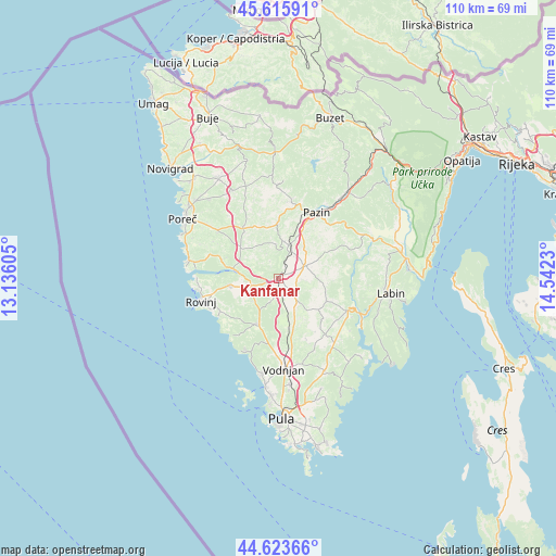
Kanfanar GPS coordinates[2]
45° 7' 18.984" North, 13° 50' 21.012" East
| Map corner | latitude | longitude |
|---|---|---|
| Upper-left | 45.61591°, | 13.13605° |
| Center: | 45.12194°, | 13.83917° |
| Lower-right: | 44.62366°, | 14.5423° |
| Map W x H: | 110.3×110.3 km | = 68.5×68.5mi |
| max Lat: | 46.52694° ⇑72.4% North |
| Kanfanar: | 45.12194° |
| min Lat: | ⇓27.6% South 42.54972° |
| min Long | Kanfanar | max Long |
| 13.52389° | 13.83917° | 19.37694° |
| W 2%⇐ | ⇒98% E |
Elevation
Elevation of Kanfanar is 285 m = 935 ft, and this is 131.7 m = 432 ft above average elevation for this country.
| Max E: |
827 m = 2713 ft | 10.7% |
| Kanfanar | 285 m 935 ft | |
| Avg. | 153.3 m = 503 ft | |
Min E: |
-1 m = -3 ft | 89.3% |
See also: Croatia elevation on elevation.city.
Geographical zone
Kanfanar is located in North temperate zone (between Tropic of Cancer and the Arctic Circle). Distance of this North polar circle is 2384.1 km =1481.4 mi to North.| Distance of | km | miles | from Kanfanar |
|---|---|---|---|
| North Pole | 4990 | 3100.6 | to North |
| Arctic Circle | 2384.1 | 1481.4 | to North |
| Tropic Cancer | 2411.2 | 1498.2 | to South |
| Equator | 5017.1 | 3117.5 | to South |


Nearby cities:
15 places around Kanfanar: (largest is in red/bold)
• Bale
10 km =6.2 mi,  205°
205°
• Barban
15.1 km =9.4 mi,  115°
115°
• Funtana
19.3 km =12 mi,  287°
287°
• Gorica
14 km =8.7 mi,  80°
80°
• Gračišće
17.2 km =10.7 mi,  51°
51°
• Pazin
15.2 km =9.4 mi,  30°
30°
• Pićan
18.5 km =11.5 mi,  59°
59°
• Rovinj
16.3 km =10.1 mi,  253°
253°
• Sveti Lovreč Pazenatički
9.7 km =6 mi,  308°
308°
• Sveti Petar u Šumi
7.2 km =4.5 mi,  18°
18°
• Svetvinčenat
5.1 km =3.2 mi,  137°
137°
• Tinjan
10.7 km =6.6 mi,  0°
0°
• Vodnjan
18.1 km =11.2 mi,  176°
176°
• Vrsar
18.6 km =11.6 mi,  279°
279°
• Žminj
5.9 km =3.7 mi,  67°
67°
Sources, notices
• [Note1] Compared only with cities in Croatia existing in our database
• [Src1] Map data: © OpenStreetMap contributors (CC-BY-SA)
• [Src2] Other city data from geonames.org with taken over terms of usage.
• [Src3] Geographical zone / Annual Mean Temperature by Robert A. Rohde @ Wikipedia
