Gračišće geodata
Gračišće (Istria) is a seat of a second-order administrative division; located in Croatia in Europe/Zagreb (GMT+2) time zone. In our database, there are 904 cities with bigger population. Compared to other cities in Croatia, 65.8% of cities are located further ↑North; 96.5% of cities are located further →East and 95.9% of cities have lower elevation than Gračišće. Note1


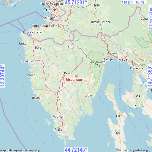
Gračišće GPS coordinates[2]
45° 13' 8.004" North, 14° 0' 38.016" East
| Map corner | latitude | longitude |
|---|---|---|
| Upper-left | 45.71201°, | 13.30744° |
| Center: | 45.21889°, | 14.01056° |
| Lower-right: | 44.72145°, | 14.71369° |
| Map W x H: | 110.1×110.1 km | = 68.4×68.4mi |
| max Lat: | 46.52694° ⇑65.8% North |
| Gračišće: | 45.21889° |
| min Lat: | ⇓34.2% South 42.54972° |
| min Long | Gračišće | max Long |
| 13.52389° | 14.01056° | 19.37694° |
| W 3.5%⇐ | ⇒96.5% E |
Elevation
Elevation of Gračišće is 443 m = 1453 ft, and this is 289.7 m = 950 ft above average elevation for this country.
| Max E: |
827 m = 2713 ft | 4.1% |
| Gračišće | 443 m 1453 ft | |
| Avg. | 153.3 m = 503 ft | |
Min E: |
-1 m = -3 ft | 95.9% |
See also: Croatia elevation on elevation.city.
Geographical zone
Gračišće is located in North temperate zone (between Tropic of Cancer and the Arctic Circle). Distance of this North polar circle is 2373.3 km =1474.7 mi to North.| Distance of | km | miles | from Gračišće |
|---|---|---|---|
| North Pole | 4979.2 | 3093.9 | to North |
| Arctic Circle | 2373.3 | 1474.7 | to North |
| Tropic Cancer | 2422 | 1505 | to South |
| Equator | 5027.9 | 3124.2 | to South |


Nearby cities:
15 places around Gračišće: (largest is in red/bold)
• Barban
17.2 km =10.7 mi,  179°
179°
• Cerovlje
6.6 km =4.1 mi,  1°
1°
• Gorica
8.6 km =5.3 mi, 177°
• Kanfanar
17.2 km =10.7 mi,  231°
231°
• Kršan
11.2 km =7 mi,  116°
116°
• Labin
16.2 km =10.1 mi,  148°
148°
• Nedeščina
11.8 km =7.3 mi,  137°
137°
• Pazin
6.3 km =3.9 mi,  292°
292°
• Pićan
2.9 km =1.8 mi, 119°
• Potpićan
7.6 km =4.7 mi, 115°
• Raša
16.3 km =10.1 mi,  160°
160°
• Sveti Petar u Šumi
11.8 km =7.3 mi,  250°
250°
• Tinjan
13.4 km =8.3 mi,  269°
269°
• Vinež
15.4 km =9.6 mi, 150°
• Žminj
11.6 km =7.2 mi,  223°
223°
Sources, notices
• [Note1] Compared only with cities in Croatia existing in our database
• [Src1] Map data: © OpenStreetMap contributors (CC-BY-SA)
• [Src2] Other city data from geonames.org with taken over terms of usage.
• [Src3] Geographical zone / Annual Mean Temperature by Robert A. Rohde @ Wikipedia
