Labin geodata
Labin (Istria) is a seat of a second-order administrative division; located in Croatia in Europe/Zagreb (GMT+2) time zone. With population of 7,943 people, there are 48 cities with bigger population in this country. Compared to other cities in Croatia, 73.4% of cities are located further ↑North; 95.6% of cities are located further →East and 81.3% of cities have lower elevation than Labin. Note1


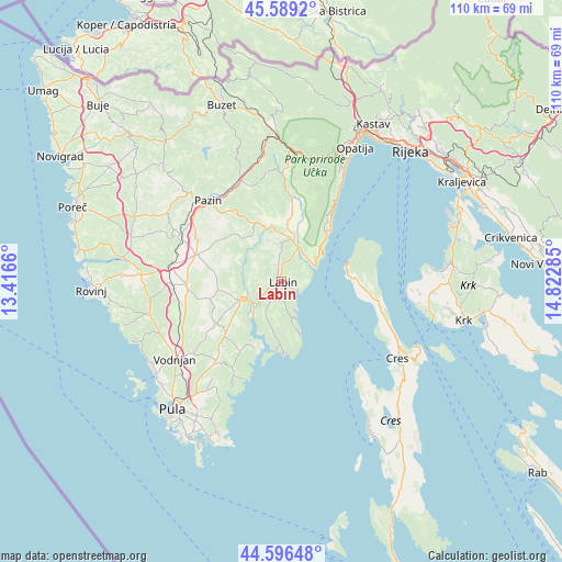
Labin GPS coordinates[2]
45° 5' 42" North, 14° 7' 10.992" East
| Map corner | latitude | longitude |
|---|---|---|
| Upper-left | 45.5892°, | 13.4166° |
| Center: | 45.095°, | 14.11972° |
| Lower-right: | 44.59648°, | 14.82285° |
| Map W x H: | 110.4×110.4 km | = 68.6×68.6mi |
| max Lat: | 46.52694° ⇑73.4% North |
| Labin: | 45.095° |
| min Lat: | ⇓26.6% South 42.54972° |
| min Long | Labin | max Long |
| 13.52389° | 14.11972° | 19.37694° |
| W 4.4%⇐ | ⇒95.6% E |
Elevation
Elevation of Labin is 214 m = 702 ft, and this is 60.7 m = 199 ft above average elevation for this country.
| Max E: |
827 m = 2713 ft | 18.7% |
| Labin | 214 m 702 ft | |
| Avg. | 153.3 m = 503 ft | |
Min E: |
-1 m = -3 ft | 81.3% |
See also: Croatia elevation on elevation.city.
Geographical zone
Labin is located in North temperate zone (between Tropic of Cancer and the Arctic Circle). Distance of this North polar circle is 2387.1 km =1483.3 mi to North.| Distance of | km | miles | from Labin |
|---|---|---|---|
| North Pole | 4993 | 3102.5 | to North |
| Arctic Circle | 2387.1 | 1483.3 | to North |
| Tropic Cancer | 2408.2 | 1496.4 | to South |
| Equator | 5014.1 | 3115.6 | to South |


Nearby cities:
15 places around Labin: (largest is in red/bold)
• Barban
9 km =5.6 mi,  247°
247°
• Gorica
9.7 km =6 mi,  302°
302°
• Gračišće
16.2 km =10.1 mi,  328°
328°
• Kršan
8.8 km =5.5 mi,  9°
9°
• Marčana
20.3 km =12.6 mi,  219°
219°
• Mošćenička Draga
19 km =11.8 mi,  33°
33°
• Nedeščina
5 km =3.1 mi,  353°
353°
• Pazin
21.6 km =13.4 mi,  318°
318°
• Pićan
13.7 km =8.5 mi, 333°
• Potpićan
10.6 km =6.6 mi, 350°
• Rabac
3.4 km =2.1 mi,  120°
120°
• Raša
3.6 km =2.2 mi,  242°
242°
• Svetvinčenat
18.6 km =11.6 mi,  267°
267°
• Vinež
1.1 km =0.7 mi,  288°
288°
• Žminj
17.4 km =10.8 mi, 287°
Sources, notices
• [Note1] Compared only with cities in Croatia existing in our database
• [Src1] Map data: © OpenStreetMap contributors (CC-BY-SA)
• [Src2] Other city data from geonames.org with taken over terms of usage.
• [Src3] Geographical zone / Annual Mean Temperature by Robert A. Rohde @ Wikipedia
