Crnac geodata
Crnac (Virovitičk-Podravska) is a seat of a second-order administrative division; located in Croatia in Europe/Zagreb (GMT+2) time zone. In our database, there are 904 cities with bigger population. Compared to other cities in Croatia, 64.4% of cities are located further ↓South; 81% of cities are located further ←West and 70.1% of cities have higher elevation than Crnac. Note1


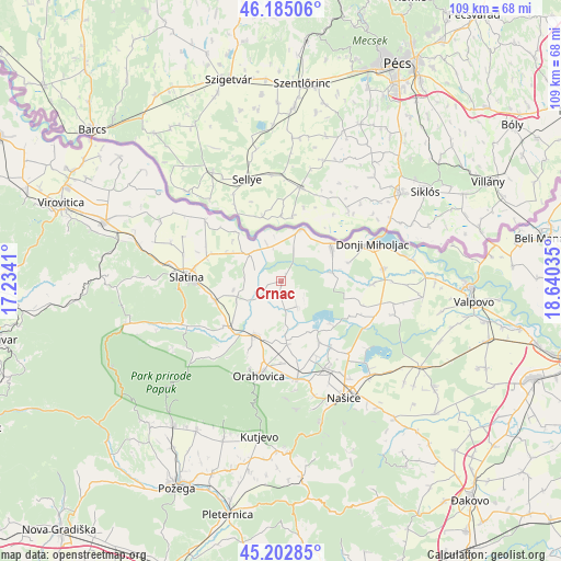
Crnac GPS coordinates[2]
45° 41' 45.996" North, 17° 56' 13.992" East
| Map corner | latitude | longitude |
|---|---|---|
| Upper-left | 46.18506°, | 17.2341° |
| Center: | 45.69611°, | 17.93722° |
| Lower-right: | 45.20285°, | 18.64035° |
| Map W x H: | 109.2×109.2 km | = 67.9×67.9mi |
| max Lat: | 46.52694° ⇑35.6% North |
| Crnac: | 45.69611° |
| min Lat: | ⇓64.4% South 42.54972° |
| min Long | Crnac | max Long |
| 13.52389° | 17.93722° | 19.37694° |
| W 81%⇐ | ⇒19% E |
Elevation
Elevation of Crnac is 94 m = 308 ft, and this is 59.3 m = 195 ft below average elevation for this country.
| Max E: |
827 m = 2713 ft | 70.1% |
| Avg. | 153.3 m = 503 ft | |
| Crnac | 94 m = 308 ft | |
Min E: |
-1 m = -3 ft | 29.9% |
See also: Croatia elevation on elevation.city.
Geographical zone
Crnac is located in North temperate zone (between Tropic of Cancer and the Arctic Circle). Distance of this North polar circle is 2320.2 km =1441.7 mi to North.| Distance of | km | miles | from Crnac |
|---|---|---|---|
| North Pole | 4926.1 | 3060.9 | to North |
| Arctic Circle | 2320.2 | 1441.7 | to North |
| Tropic Cancer | 2475 | 1537.9 | to South |
| Equator | 5080.9 | 3157.1 | to South |


Nearby cities:
15 places around Crnac: (largest is in red/bold)
• Beljevina
15.8 km =9.8 mi,  157°
157°
• Feričanci
18.8 km =11.7 mi,  170°
170°
• Kozice
15.9 km =9.9 mi,  264°
264°
• Mikleuš
13.5 km =8.4 mi,  230°
230°
• Nova Bukovica
13.7 km =8.5 mi, 255°
• Orahovica
17.8 km =11.1 mi,  193°
193°
• Podravska Moslavina
10.6 km =6.6 mi,  19°
19°
• Slatina
18.2 km =11.3 mi,  272°
272°
• Sopje
19.1 km =11.9 mi,  307°
307°
• Viljevo
11.5 km =7.1 mi,  57°
57°
• Zdenci
11.9 km =7.4 mi,  175°
175°
• Ðurđenovac
19 km =11.8 mi,  153°
153°
• Čačinci
11.5 km =7.1 mi,  206°
206°
• Čađavica
8.3 km =5.2 mi, 309°
• Šaptinovci
16.1 km =10 mi,  143°
143°
Sources, notices
• [Note1] Compared only with cities in Croatia existing in our database
• [Src1] Map data: © OpenStreetMap contributors (CC-BY-SA)
• [Src2] Other city data from geonames.org with taken over terms of usage.
• [Src3] Geographical zone / Annual Mean Temperature by Robert A. Rohde @ Wikipedia
