Peteranec geodata
Peteranec (Koprivničko-Križevačka) is a seat of a second-order administrative division; located in Croatia in Europe/Zagreb (GMT+2) time zone. With population of 1,538 people, there are 289 cities with bigger population in this country. Compared to other cities in Croatia, 88.2% of cities are located further ↓South; 65.3% of cities are located further ←West and 50.5% of cities have higher elevation than Peteranec. Note1


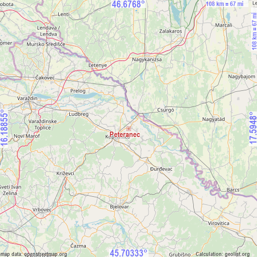
Peteranec GPS coordinates[2]
46° 11' 31.992" North, 16° 53' 30.012" East
| Map corner | latitude | longitude |
|---|---|---|
| Upper-left | 46.6768°, | 16.18855° |
| Center: | 46.19222°, | 16.89167° |
| Lower-right: | 45.70333°, | 17.5948° |
| Map W x H: | 108.2×108.2 km | = 67.2×67.2mi |
| max Lat: | 46.52694° ⇑11.8% North |
| Peteranec: | 46.19222° |
| min Lat: | ⇓88.2% South 42.54972° |
| min Long | Peteranec | max Long |
| 13.52389° | 16.89167° | 19.37694° |
| W 65.3%⇐ | ⇒34.7% E |
Elevation
Elevation of Peteranec is 126 m = 413 ft, and this is 27.3 m = 90 ft below average elevation for this country.
| Max E: |
827 m = 2713 ft | 50.5% |
| Avg. | 153.3 m = 503 ft | |
| Peteranec | 126 m = 413 ft | |
Min E: |
-1 m = -3 ft | 49.5% |
See also: Croatia elevation on elevation.city.
Geographical zone
Peteranec is located in North temperate zone (between Tropic of Cancer and the Arctic Circle). Distance of this North polar circle is 2265.1 km =1407.5 mi to North.| Distance of | km | miles | from Peteranec |
|---|---|---|---|
| North Pole | 4871 | 3026.7 | to North |
| Arctic Circle | 2265.1 | 1407.5 | to North |
| Tropic Cancer | 2530.2 | 1572.2 | to South |
| Equator | 5136.1 | 3191.4 | to South |


Nearby cities:
15 places around Peteranec: (largest is in red/bold)
• Drnje
2.5 km =1.6 mi,  49°
49°
• Glogovac
8.6 km =5.3 mi,  188°
188°
• Gola
12.8 km =8 mi,  88°
88°
• Herešin
2.3 km =1.4 mi,  232°
232°
• Hlebine
6.7 km =4.2 mi,  125°
125°
• Koprivnica
5.9 km =3.7 mi,  236°
236°
• Koprivnički Bregi
6.1 km =3.8 mi,  169°
169°
• Koprivnički Ivanec
5.9 km =3.7 mi,  281°
281°
• Legrad
12 km =7.5 mi,  347°
347°
• Novigrad Podravski
13.6 km =8.5 mi,  159°
159°
• Reka
11.8 km =7.3 mi, 234°
• Sigetec
3.4 km =2.1 mi,  97°
97°
• Subotica Podravska
10.9 km =6.8 mi,  264°
264°
• Torčec
3.5 km =2.2 mi, 351°
• Ðelekovec
6.6 km =4.1 mi,  342°
342°
Sources, notices
• [Note1] Compared only with cities in Croatia existing in our database
• [Src1] Map data: © OpenStreetMap contributors (CC-BY-SA)
• [Src2] Other city data from geonames.org with taken over terms of usage.
• [Src3] Geographical zone / Annual Mean Temperature by Robert A. Rohde @ Wikipedia
