Sigetec geodata
Sigetec (Koprivničko-Križevačka) is a populated place; located in Croatia in Europe/Zagreb (GMT+2) time zone. With population of 1,212 people, there are 373 cities with bigger population in this country. Compared to other cities in Croatia, 88.1% of cities are located further ↓South; 66.8% of cities are located further ←West and 51.3% of cities have higher elevation than Sigetec. Note1


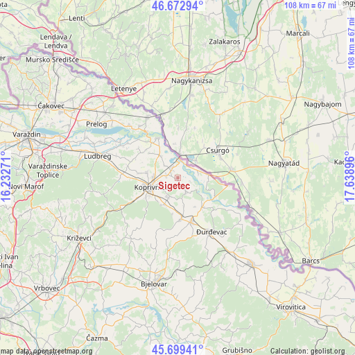
Sigetec GPS coordinates[2]
46° 11' 17.988" North, 16° 56' 8.988" East
| Map corner | latitude | longitude |
|---|---|---|
| Upper-left | 46.67294°, | 16.23271° |
| Center: | 46.18833°, | 16.93583° |
| Lower-right: | 45.69941°, | 17.63896° |
| Map W x H: | 108.2×108.2 km | = 67.2×67.2mi |
| max Lat: | 46.52694° ⇑11.9% North |
| Sigetec: | 46.18833° |
| min Lat: | ⇓88.1% South 42.54972° |
| min Long | Sigetec | max Long |
| 13.52389° | 16.93583° | 19.37694° |
| W 66.8%⇐ | ⇒33.2% E |
Elevation
Elevation of Sigetec is 125 m = 410 ft, and this is 28.3 m = 93 ft below average elevation for this country.
| Max E: |
827 m = 2713 ft | 51.3% |
| Avg. | 153.3 m = 503 ft | |
| Sigetec | 125 m = 410 ft | |
Min E: |
-1 m = -3 ft | 48.7% |
See also: Croatia elevation on elevation.city.
Geographical zone
Sigetec is located in North temperate zone (between Tropic of Cancer and the Arctic Circle). Distance of this North polar circle is 2265.5 km =1407.7 mi to North.| Distance of | km | miles | from Sigetec |
|---|---|---|---|
| North Pole | 4871.4 | 3026.9 | to North |
| Arctic Circle | 2265.5 | 1407.7 | to North |
| Tropic Cancer | 2529.7 | 1571.9 | to South |
| Equator | 5135.7 | 3191.2 | to South |


Nearby cities:
15 places around Sigetec: (largest is in red/bold)
• Drnje
2.5 km =1.6 mi,  324°
324°
• Glogovac
9.4 km =5.8 mi,  210°
210°
• Gola
9.4 km =5.8 mi,  84°
84°
• Herešin
5.3 km =3.3 mi,  259°
259°
• Hlebine
4.1 km =2.5 mi,  149°
149°
• Koprivnica
8.8 km =5.5 mi,  251°
251°
• Koprivnički Bregi
6 km =3.7 mi,  202°
202°
• Koprivnički Ivanec
9.3 km =5.8 mi,  279°
279°
• Legrad
13.6 km =8.5 mi,  333°
333°
• Molve
11.5 km =7.1 mi,  140°
140°
• Novigrad Podravski
12.3 km =7.6 mi,  173°
173°
• Peteranec
3.4 km =2.1 mi, 277°
• Torčec
5.5 km =3.4 mi,  314°
314°
• Virje
14.1 km =8.8 mi,  162°
162°
• Ðelekovec
8.6 km =5.3 mi, 321°
Sources, notices
• [Note1] Compared only with cities in Croatia existing in our database
• [Src1] Map data: © OpenStreetMap contributors (CC-BY-SA)
• [Src2] Other city data from geonames.org with taken over terms of usage.
• [Src3] Geographical zone / Annual Mean Temperature by Robert A. Rohde @ Wikipedia
