Orehovica geodata
Orehovica (Međimurska) is a seat of a second-order administrative division; located in Croatia in Europe/Zagreb (GMT+2) time zone. With population of 1,667 people, there are 255 cities with bigger population in this country. Compared to other cities in Croatia, 94.7% of cities are located further ↓South; 52% of cities are located further ←West and 67.2% of cities have lower elevation than Orehovica. Note1


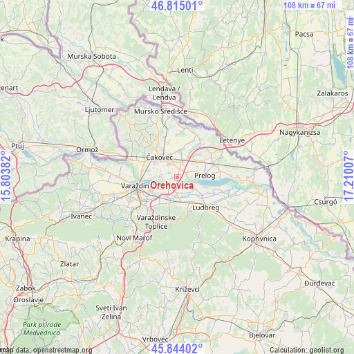
Orehovica GPS coordinates[2]
46° 19' 54.012" North, 16° 30' 24.984" East
| Map corner | latitude | longitude |
|---|---|---|
| Upper-left | 46.81501°, | 15.80382° |
| Center: | 46.33167°, | 16.50694° |
| Lower-right: | 45.84402°, | 17.21007° |
| Map W x H: | 108×108 km | = 67.1×67.1mi |
| max Lat: | 46.52694° ⇑5.3% North |
| Orehovica: | 46.33167° |
| min Lat: | ⇓94.7% South 42.54972° |
| min Long | Orehovica | max Long |
| 13.52389° | 16.50694° | 19.37694° |
| W 52%⇐ | ⇒48% E |
Elevation
Elevation of Orehovica is 159 m = 522 ft, and this is 5.7 m = 19 ft above average elevation for this country.
| Max E: |
827 m = 2713 ft | 32.8% |
| Orehovica | 159 m 522 ft | |
| Avg. | 153.3 m = 503 ft | |
Min E: |
-1 m = -3 ft | 67.2% |
See also: Croatia elevation on elevation.city.
Geographical zone
Orehovica is located in North temperate zone (between Tropic of Cancer and the Arctic Circle). Distance of this North polar circle is 2249.6 km =1397.8 mi to North.| Distance of | km | miles | from Orehovica |
|---|---|---|---|
| North Pole | 4855.5 | 3017.1 | to North |
| Arctic Circle | 2249.6 | 1397.8 | to North |
| Tropic Cancer | 2545.7 | 1581.8 | to South |
| Equator | 5151.6 | 3201.1 | to South |


Nearby cities:
15 places around Orehovica: (largest is in red/bold)
• Bartolovec
6.3 km =3.9 mi,  233°
233°
• Belica
8.1 km =5 mi,  6°
6°
• Hrženica
6.4 km =4 mi,  125°
125°
• Ivanovec
4.7 km =2.9 mi,  330°
330°
• Kuršanec
8.1 km =5 mi,  268°
268°
• Mala Subotica
5.2 km =3.2 mi,  18°
18°
• Martijanec
7.7 km =4.8 mi,  160°
160°
• Novo Selo na Dravi
5.7 km =3.5 mi, 269°
• Palovec
7.1 km =4.4 mi,  26°
26°
• Podbrest
2.9 km =1.8 mi,  90°
90°
• Pribislavec
7 km =4.3 mi,  344°
344°
• Totovec
5.1 km =3.2 mi,  280°
280°
• Vrbanovec
7.5 km =4.7 mi,  172°
172°
• Šemovec
4.2 km =2.6 mi,  222°
222°
• Štefanec
4.2 km =2.6 mi,  348°
348°
Sources, notices
• [Note1] Compared only with cities in Croatia existing in our database
• [Src1] Map data: © OpenStreetMap contributors (CC-BY-SA)
• [Src2] Other city data from geonames.org with taken over terms of usage.
• [Src3] Geographical zone / Annual Mean Temperature by Robert A. Rohde @ Wikipedia
