Pučišća geodata
Pučišća (Split-Dalmatia) is a populated place; located in Croatia in Europe/Zagreb (GMT+2) time zone. With population of 1,529 people, there are 293 cities with bigger population in this country. Compared to other cities in Croatia, 94.8% of cities are located further ↑North; 61.3% of cities are located further ←West and 95.7% of cities have higher elevation than Pučišća. Note1


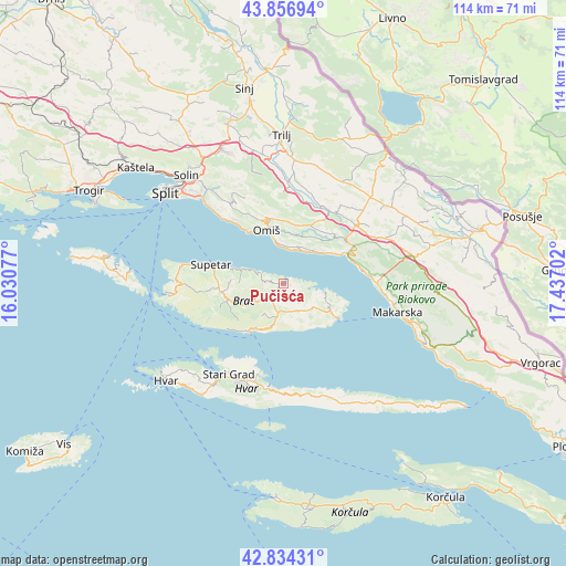
Pučišća GPS coordinates[2]
43° 20' 52.008" North, 16° 44' 2.004" East
| Map corner | latitude | longitude |
|---|---|---|
| Upper-left | 43.85694°, | 16.03077° |
| Center: | 43.34778°, | 16.73389° |
| Lower-right: | 42.83431°, | 17.43702° |
| Map W x H: | 113.7×113.7 km | = 70.6×70.6mi |
| max Lat: | 46.52694° ⇑94.8% North |
| Pučišća: | 43.34778° |
| min Lat: | ⇓5.2% South 42.54972° |
| min Long | Pučišća | max Long |
| 13.52389° | 16.73389° | 19.37694° |
| W 61.3%⇐ | ⇒38.7% E |
Elevation
Elevation of Pučišća is 8 m = 26 ft, and this is 145.3 m = 477 ft below average elevation for this country.
| Max E: |
827 m = 2713 ft | 95.7% |
| Avg. | 153.3 m = 503 ft | |
| Pučišća | 8 m = 26 ft | |
Min E: |
-1 m = -3 ft | 4.3% |
See also: Croatia elevation on elevation.city.
Geographical zone
Pučišća is located in North temperate zone (between Tropic of Cancer and the Arctic Circle). Distance of this Northern Tropic circle is 2213.9 km =1375.7 mi to South.| Distance of | km | miles | from Pučišća |
|---|---|---|---|
| North Pole | 5187.2 | 3223.2 | to North |
| Arctic Circle | 2581.4 | 1604 | to North |
| Tropic Cancer | 2213.9 | 1375.7 | to South |
| Equator | 4819.8 | 2994.9 | to South |


Nearby cities:
15 places around Pučišća: (largest is in red/bold)
• Bol
11.5 km =7.1 mi,  213°
213°
• Brela
16.4 km =10.2 mi,  81°
81°
• Dugi Rat
13.3 km =8.3 mi,  325°
325°
• Duće
11.8 km =7.3 mi, 333°
• Gata
13.5 km =8.4 mi,  348°
348°
• Kostanje
13.1 km =8.1 mi,  37°
37°
• Kučiće
10.9 km =6.8 mi,  29°
29°
• Nerežišće
12.7 km =7.9 mi,  261°
261°
• Omiš
11.4 km =7.1 mi,  341°
341°
• Postira
8.9 km =5.5 mi,  290°
290°
• Selca
11 km =6.8 mi,  120°
120°
• Stanići
7.4 km =4.6 mi,  356°
356°
• Supetar
15.3 km =9.5 mi, 285°
• Tugare
14.3 km =8.9 mi, 337°
• Zadvarje
15.7 km =9.8 mi,  53°
53°
Sources, notices
• [Note1] Compared only with cities in Croatia existing in our database
• [Src1] Map data: © OpenStreetMap contributors (CC-BY-SA)
• [Src2] Other city data from geonames.org with taken over terms of usage.
• [Src3] Geographical zone / Annual Mean Temperature by Robert A. Rohde @ Wikipedia
