Lumbarda geodata
Lumbarda (Dubrovačko-Neretvanska) is a seat of a second-order administrative division; located in Croatia in Europe/Zagreb (GMT+2) time zone. With population of 1,227 people, there are 367 cities with bigger population in this country. Compared to other cities in Croatia, 98.2% of cities are located further ↑North; 70.8% of cities are located further ←West and 91.1% of cities have higher elevation than Lumbarda. Note1


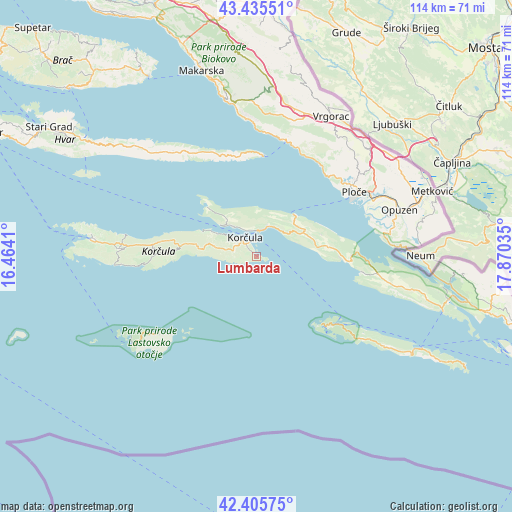
Lumbarda GPS coordinates[2]
42° 55' 22.008" North, 17° 10' 1.992" East
| Map corner | latitude | longitude |
|---|---|---|
| Upper-left | 43.43551°, | 16.4641° |
| Center: | 42.92278°, | 17.16722° |
| Lower-right: | 42.40575°, | 17.87035° |
| Map W x H: | 114.5×114.5 km | = 71.1×71.1mi |
| max Lat: | 46.52694° ⇑98.2% North |
| Lumbarda: | 42.92278° |
| min Lat: | ⇓1.8% South 42.54972° |
| min Long | Lumbarda | max Long |
| 13.52389° | 17.16722° | 19.37694° |
| W 70.8%⇐ | ⇒29.2% E |
Elevation
Elevation of Lumbarda is 18 m = 59 ft, and this is 135.3 m = 444 ft below average elevation for this country.
| Max E: |
827 m = 2713 ft | 91.1% |
| Avg. | 153.3 m = 503 ft | |
| Lumbarda | 18 m = 59 ft | |
Min E: |
-1 m = -3 ft | 8.9% |
See also: Croatia elevation on elevation.city.
Geographical zone
Lumbarda is located in North temperate zone (between Tropic of Cancer and the Arctic Circle). Distance of this Northern Tropic circle is 2166.6 km =1346.3 mi to South.| Distance of | km | miles | from Lumbarda |
|---|---|---|---|
| North Pole | 5234.5 | 3252.6 | to North |
| Arctic Circle | 2628.6 | 1633.3 | to North |
| Tropic Cancer | 2166.6 | 1346.3 | to South |
| Equator | 4772.6 | 2965.6 | to South |


Nearby cities:
15 places around Lumbarda: (largest is in red/bold)
• Blato
30.6 km =19 mi,  273°
273°
• Gradac
24.8 km =15.4 mi,  34°
34°
• Janjina
21.3 km =13.2 mi,  89°
89°
• Korčula
4.9 km =3 mi,  328°
328°
• Kraj
25.8 km =16 mi,  20°
20°
• Lastovo
28 km =17.4 mi,  231°
231°
• Orebić
7 km =4.3 mi,  4°
4°
• Ploče
26.2 km =16.3 mi,  55°
55°
• Rogotin
29 km =18 mi, 61°
• Smokvica
22.1 km =13.7 mi, 272°
• Sućuraj
22.6 km =14 mi, 3°
• Trpanj
12.9 km =8 mi,  42°
42°
• Vlaka
30.3 km =18.8 mi,  73°
73°
• Čara
19 km =11.8 mi,  275°
275°
• Žrnovo
5.3 km =3.3 mi,  306°
306°
Sources, notices
• [Note1] Compared only with cities in Croatia existing in our database
• [Src1] Map data: © OpenStreetMap contributors (CC-BY-SA)
• [Src2] Other city data from geonames.org with taken over terms of usage.
• [Src3] Geographical zone / Annual Mean Temperature by Robert A. Rohde @ Wikipedia
