Pazin geodata
Pazin (Istria) is a seat of a first-order administrative division; located in Croatia in Europe/Zagreb (GMT+2) time zone. With population of 5,010 people, there are 80 cities with bigger population in this country. Compared to other cities in Croatia, 63.6% of cities are located further ↑North; 96.8% of cities are located further →East and 88% of cities have lower elevation than Pazin. Note1


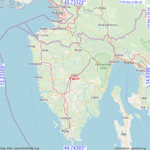
Pazin GPS coordinates[2]
45° 14' 25.008" North, 13° 56' 12.012" East
| Map corner | latitude | longitude |
|---|---|---|
| Upper-left | 45.73322°, | 13.23355° |
| Center: | 45.24028°, | 13.93667° |
| Lower-right: | 44.74303°, | 14.6398° |
| Map W x H: | 110.1×110.1 km | = 68.4×68.4mi |
| max Lat: | 46.52694° ⇑63.6% North |
| Pazin: | 45.24028° |
| min Lat: | ⇓36.4% South 42.54972° |
| min Long | Pazin | max Long |
| 13.52389° | 13.93667° | 19.37694° |
| W 3.2%⇐ | ⇒96.8% E |
Elevation
Elevation of Pazin is 268 m = 879 ft, and this is 114.7 m = 376 ft above average elevation for this country.
| Max E: |
827 m = 2713 ft | 12% |
| Pazin | 268 m 879 ft | |
| Avg. | 153.3 m = 503 ft | |
Min E: |
-1 m = -3 ft | 88% |
See also: Croatia elevation on elevation.city.
Geographical zone
Pazin is located in North temperate zone (between Tropic of Cancer and the Arctic Circle). Distance of this North polar circle is 2370.9 km =1473.2 mi to North.| Distance of | km | miles | from Pazin |
|---|---|---|---|
| North Pole | 4976.8 | 3092.4 | to North |
| Arctic Circle | 2370.9 | 1473.2 | to North |
| Tropic Cancer | 2424.3 | 1506.4 | to South |
| Equator | 5030.2 | 3125.6 | to South |


Nearby cities:
15 places around Pazin: (largest is in red/bold)
• Cerovlje
7.3 km =4.5 mi,  54°
54°
• Gorica
12.6 km =7.8 mi,  150°
150°
• Gračišće
6.3 km =3.9 mi,  112°
112°
• Kanfanar
15.2 km =9.4 mi,  210°
210°
• Karojba
11.2 km =7 mi,  307°
307°
• Motovun
13.6 km =8.5 mi,  321°
321°
• Pićan
9.1 km =5.7 mi, 114°
• Potpićan
13.9 km =8.6 mi, 114°
• Sveti Lovreč Pazenatički
16.9 km =10.5 mi,  244°
244°
• Sveti Petar u Šumi
8.3 km =5.2 mi,  220°
220°
• Svetvinčenat
17.4 km =10.8 mi,  193°
193°
• Tinjan
8 km =5 mi,  252°
252°
• Visignano
17.4 km =10.8 mi,  283°
283°
• Vižinada
17.1 km =10.6 mi, 305°
• Žminj
11.1 km =6.9 mi, 191°
Sources, notices
• [Note1] Compared only with cities in Croatia existing in our database
• [Src1] Map data: © OpenStreetMap contributors (CC-BY-SA)
• [Src2] Other city data from geonames.org with taken over terms of usage.
• [Src3] Geographical zone / Annual Mean Temperature by Robert A. Rohde @ Wikipedia
