Kapelica geodata
Kapelica (Bjelovarsko-Bilogorska) is a populated place; located in Croatia in Europe/Zagreb (GMT+2) time zone. With population of 546 people, there are 819 cities with bigger population in this country. Compared to other cities in Croatia, 57.3% of cities are located further ↓South; 65.4% of cities are located further ←West and 71.7% of cities have lower elevation than Kapelica. Note1


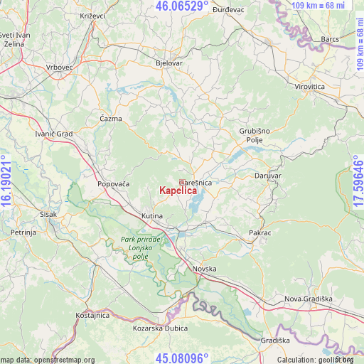
Kapelica GPS coordinates[2]
45° 34' 31.008" North, 16° 53' 35.988" East
| Map corner | latitude | longitude |
|---|---|---|
| Upper-left | 46.06529°, | 16.19021° |
| Center: | 45.57528°, | 16.89333° |
| Lower-right: | 45.08096°, | 17.59646° |
| Map W x H: | 109.4×109.4 km | = 68×68mi |
| max Lat: | 46.52694° ⇑42.7% North |
| Kapelica: | 45.57528° |
| min Lat: | ⇓57.3% South 42.54972° |
| min Long | Kapelica | max Long |
| 13.52389° | 16.89333° | 19.37694° |
| W 65.4%⇐ | ⇒34.6% E |
Elevation
Elevation of Kapelica is 171 m = 561 ft, and this is 17.7 m = 58 ft above average elevation for this country.
| Max E: |
827 m = 2713 ft | 28.3% |
| Kapelica | 171 m 561 ft | |
| Avg. | 153.3 m = 503 ft | |
Min E: |
-1 m = -3 ft | 71.7% |
See also: Croatia elevation on elevation.city.
Geographical zone
Kapelica is located in North temperate zone (between Tropic of Cancer and the Arctic Circle). Distance of this North polar circle is 2333.7 km =1450.1 mi to North.| Distance of | km | miles | from Kapelica |
|---|---|---|---|
| North Pole | 4939.6 | 3069.3 | to North |
| Arctic Circle | 2333.7 | 1450.1 | to North |
| Tropic Cancer | 2461.6 | 1529.6 | to South |
| Equator | 5067.5 | 3148.8 | to South |


Nearby cities:
15 places around Kapelica: (largest is in red/bold)
• Banova Jaruga
14.9 km =9.3 mi,  176°
176°
• Dežanovac
15.1 km =9.4 mi,  91°
91°
• Garešnica
3.7 km =2.3 mi, 91°
• Gornja Gračenica
16.9 km =10.5 mi,  245°
245°
• Gornja Jelenska
15.3 km =9.5 mi,  280°
280°
• Hercegovac
13.2 km =8.2 mi,  45°
45°
• Husain
12.9 km =8 mi,  209°
209°
• Ilova
13.8 km =8.6 mi,  186°
186°
• Kutina
14.1 km =8.8 mi,  217°
217°
• Kutinska Slatina
10.8 km =6.7 mi,  232°
232°
• Palešnik
9.4 km =5.8 mi,  43°
43°
• Poljana
13.5 km =8.4 mi,  149°
149°
• Repušnica
15.6 km =9.7 mi, 234°
• Velika Trnovitica
12.8 km =8 mi,  21°
21°
• Voloder
17 km =10.6 mi,  259°
259°
Sources, notices
• [Note1] Compared only with cities in Croatia existing in our database
• [Src1] Map data: © OpenStreetMap contributors (CC-BY-SA)
• [Src2] Other city data from geonames.org with taken over terms of usage.
• [Src3] Geographical zone / Annual Mean Temperature by Robert A. Rohde @ Wikipedia
