Hlapičina geodata
Hlapičina (Međimurska) is a populated place; located in Croatia in Europe/Zagreb (GMT+2) time zone. With population of 676 people, there are 688 cities with bigger population in this country. Compared to other cities in Croatia, 99.9% of cities are located further ↓South; 52.5% of cities are located further →East and 72.5% of cities have lower elevation than Hlapičina. Note1


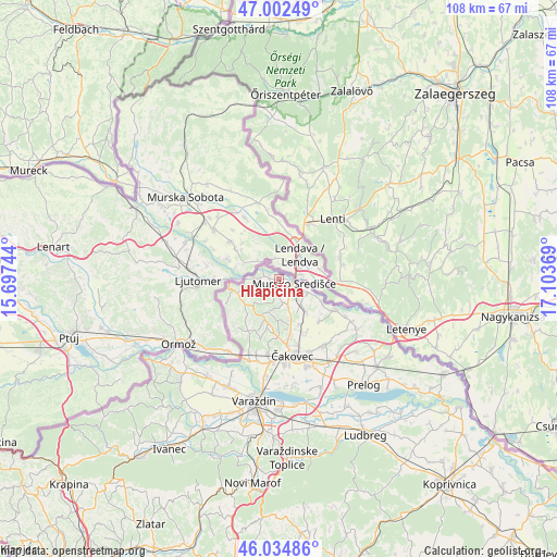
Hlapičina GPS coordinates[2]
46° 31' 14.988" North, 16° 24' 2.016" East
| Map corner | latitude | longitude |
|---|---|---|
| Upper-left | 47.00249°, | 15.69744° |
| Center: | 46.52083°, | 16.40056° |
| Lower-right: | 46.03486°, | 17.10369° |
| Map W x H: | 107.6×107.6 km | = 66.9×66.9mi |
| max Lat: | 46.52694° ⇑0.1% North |
| Hlapičina: | 46.52083° |
| min Lat: | ⇓99.9% South 42.54972° |
| min Long | Hlapičina | max Long |
| 13.52389° | 16.40056° | 19.37694° |
| W 47.5%⇐ | ⇒52.5% E |
Elevation
Elevation of Hlapičina is 173 m = 568 ft, and this is 19.7 m = 65 ft above average elevation for this country.
| Max E: |
827 m = 2713 ft | 27.5% |
| Hlapičina | 173 m 568 ft | |
| Avg. | 153.3 m = 503 ft | |
Min E: |
-1 m = -3 ft | 72.5% |
See also: Croatia elevation on elevation.city.
Geographical zone
Hlapičina is located in North temperate zone (between Tropic of Cancer and the Arctic Circle). Distance of this North polar circle is 2228.5 km =1384.7 mi to North.| Distance of | km | miles | from Hlapičina |
|---|---|---|---|
| North Pole | 4834.4 | 3004 | to North |
| Arctic Circle | 2228.5 | 1384.7 | to North |
| Tropic Cancer | 2566.7 | 1594.9 | to South |
| Equator | 5172.6 | 3214.1 | to South |


Nearby cities:
15 places around Hlapičina: (largest is in red/bold)
• Brezje
11.4 km =7.1 mi,  184°
184°
• Gornji Kraljevec
8.1 km =5 mi,  138°
138°
• Krištanovec
9.4 km =5.8 mi,  154°
154°
• Lopatinec
9.8 km =6.1 mi,  187°
187°
• Mačkovec
11 km =6.8 mi,  166°
166°
• Mursko Središće
3.4 km =2.1 mi,  112°
112°
• Novo Selo Rok
11.3 km =7 mi,  155°
155°
• Peklenica
6.4 km =4 mi,  116°
116°
• Selnica
3.2 km =2 mi,  195°
195°
• Sivica
11.2 km =7 mi, 135°
• Sveti Martin na Muri
2.1 km =1.3 mi,  289°
289°
• Vratišinec
6.5 km =4 mi, 137°
• Zasadbreg
7.7 km =4.8 mi, 175°
• Štrigova
8.8 km =5.5 mi,  256°
256°
• Žiškovec
8.3 km =5.2 mi, 162°
Sources, notices
• [Note1] Compared only with cities in Croatia existing in our database
• [Src1] Map data: © OpenStreetMap contributors (CC-BY-SA)
• [Src2] Other city data from geonames.org with taken over terms of usage.
• [Src3] Geographical zone / Annual Mean Temperature by Robert A. Rohde @ Wikipedia
