Ervenik geodata
Ervenik (Šibensko-Kniniska) is a seat of a second-order administrative division; located in Croatia in Europe/Zagreb (GMT+2) time zone. In our database, there are 904 cities with bigger population. Compared to other cities in Croatia, 82.5% of cities are located further ↑North; 70.3% of cities are located further →East and 52.9% of cities have lower elevation than Ervenik. Note1


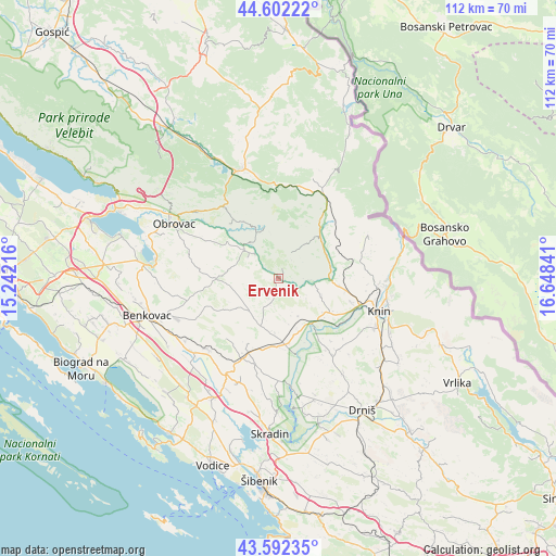
Ervenik GPS coordinates[2]
44° 5' 57.984" North, 15° 56' 43.008" East
| Map corner | latitude | longitude |
|---|---|---|
| Upper-left | 44.60222°, | 15.24216° |
| Center: | 44.09944°, | 15.94528° |
| Lower-right: | 43.59235°, | 16.64841° |
| Map W x H: | 112.3×112.3 km | = 69.8×69.8mi |
| max Lat: | 46.52694° ⇑82.5% North |
| Ervenik: | 44.09944° |
| min Lat: | ⇓17.5% South 42.54972° |
| min Long | Ervenik | max Long |
| 13.52389° | 15.94528° | 19.37694° |
| W 29.7%⇐ | ⇒70.3% E |
Elevation
Elevation of Ervenik is 132 m = 433 ft, and this is 21.3 m = 70 ft below average elevation for this country.
| Max E: |
827 m = 2713 ft | 47.1% |
| Avg. | 153.3 m = 503 ft | |
| Ervenik | 132 m = 433 ft | |
Min E: |
-1 m = -3 ft | 52.9% |
See also: Croatia elevation on elevation.city.
Geographical zone
Ervenik is located in North temperate zone (between Tropic of Cancer and the Arctic Circle). Distance of this Northern Tropic circle is 2297.5 km =1427.6 mi to South.| Distance of | km | miles | from Ervenik |
|---|---|---|---|
| North Pole | 5103.7 | 3171.3 | to North |
| Arctic Circle | 2497.8 | 1552.1 | to North |
| Tropic Cancer | 2297.5 | 1427.6 | to South |
| Equator | 4903.4 | 3046.8 | to South |


Nearby cities:
15 places around Ervenik: (largest is in red/bold)
• Biskupija
25.3 km =15.7 mi,  112°
112°
• Buković
26 km =16.2 mi,  253°
253°
• Dubravice
27.4 km =17 mi,  181°
181°
• Gornji Karin
25.2 km =15.7 mi,  279°
279°
• Gračac
23.5 km =14.6 mi,  340°
340°
• Kistanje
13.1 km =8.1 mi,  173°
173°
• Knin
21.1 km =13.1 mi, 108°
• Kninsko Polje
21.9 km =13.6 mi,  104°
104°
• Kovačić
23 km =14.3 mi, 104°
• Kruševo
25.3 km =15.7 mi,  291°
291°
• Lišane Ostrovičke
20 km =12.4 mi,  223°
223°
• Obrovac
23.8 km =14.8 mi,  298°
298°
• Oklaj
19.8 km =12.3 mi,  146°
146°
• Vukšić
24.6 km =15.3 mi,  225°
225°
• Žagrović
18.2 km =11.3 mi, 102°
Sources, notices
• [Note1] Compared only with cities in Croatia existing in our database
• [Src1] Map data: © OpenStreetMap contributors (CC-BY-SA)
• [Src2] Other city data from geonames.org with taken over terms of usage.
• [Src3] Geographical zone / Annual Mean Temperature by Robert A. Rohde @ Wikipedia
