Baška geodata
Baška (Primorsko-Goranska) is a seat of a second-order administrative division; located in Croatia in Europe/Zagreb (GMT+2) time zone. With population of 905 people, there are 521 cities with bigger population in this country. Compared to other cities in Croatia, 75.6% of cities are located further ↑North; 90.3% of cities are located further →East and 94.6% of cities have higher elevation than Baška. Note1


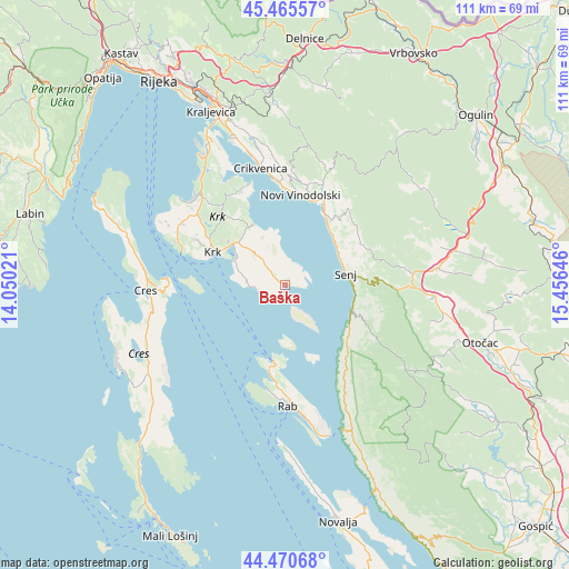
Baška GPS coordinates[2]
44° 58' 13.008" North, 14° 45' 11.988" East
| Map corner | latitude | longitude |
|---|---|---|
| Upper-left | 45.46557°, | 14.05021° |
| Center: | 44.97028°, | 14.75333° |
| Lower-right: | 44.47068°, | 15.45646° |
| Map W x H: | 110.6×110.6 km | = 68.7×68.7mi |
| max Lat: | 46.52694° ⇑75.6% North |
| Baška: | 44.97028° |
| min Lat: | ⇓24.4% South 42.54972° |
| min Long | Baška | max Long |
| 13.52389° | 14.75333° | 19.37694° |
| W 9.7%⇐ | ⇒90.3% E |
Elevation
Elevation of Baška is 10 m = 33 ft, and this is 143.3 m = 470 ft below average elevation for this country.
| Max E: |
827 m = 2713 ft | 94.6% |
| Avg. | 153.3 m = 503 ft | |
| Baška | 10 m = 33 ft | |
Min E: |
-1 m = -3 ft | 5.4% |
See also: Croatia elevation on elevation.city.
Geographical zone
Baška is located in North temperate zone (between Tropic of Cancer and the Arctic Circle). Distance of this Northern Tropic circle is 2394.3 km =1487.7 mi to South.| Distance of | km | miles | from Baška |
|---|---|---|---|
| North Pole | 5006.8 | 3111.1 | to North |
| Arctic Circle | 2400.9 | 1491.8 | to North |
| Tropic Cancer | 2394.3 | 1487.7 | to South |
| Equator | 5000.2 | 3107 | to South |


Nearby cities:
15 places around Baška: (largest is in red/bold)
• Bribir
21.2 km =13.2 mi,  2°
2°
• Crikvenica
23.5 km =14.6 mi,  348°
348°
• Dobrinj
21 km =13 mi,  325°
325°
• Kampor
21.9 km =13.6 mi,  187°
187°
• Krk
15.4 km =9.6 mi,  294°
294°
• Lopar
15.4 km =9.6 mi, 186°
• Mundanije
22.2 km =13.8 mi,  178°
178°
• Novi Vinodolski
17.8 km =11.1 mi,  9°
9°
• Punat
11 km =6.8 mi,  296°
296°
• Rab
23.7 km =14.7 mi, 178°
• Selce
20.8 km =12.9 mi, 353°
• Senj
12.2 km =7.6 mi,  79°
79°
• Supetarska Draga
19.3 km =12 mi, 186°
• Vrbnik
13.3 km =8.3 mi, 331°
• Vrh
19.7 km =12.2 mi, 296°
Sources, notices
• [Note1] Compared only with cities in Croatia existing in our database
• [Src1] Map data: © OpenStreetMap contributors (CC-BY-SA)
• [Src2] Other city data from geonames.org with taken over terms of usage.
• [Src3] Geographical zone / Annual Mean Temperature by Robert A. Rohde @ Wikipedia
