Kampor geodata
Kampor (Primorsko-Goranska) is a populated place; located in Croatia in Europe/Zagreb (GMT+1) time zone. With population of 1,173 people, there are 384 cities with bigger population in this country. Compared to other cities in Croatia, 78.2% of cities are located further ↑North; 90.8% of cities are located further →East and 86.5% of cities have higher elevation than Kampor. Note1


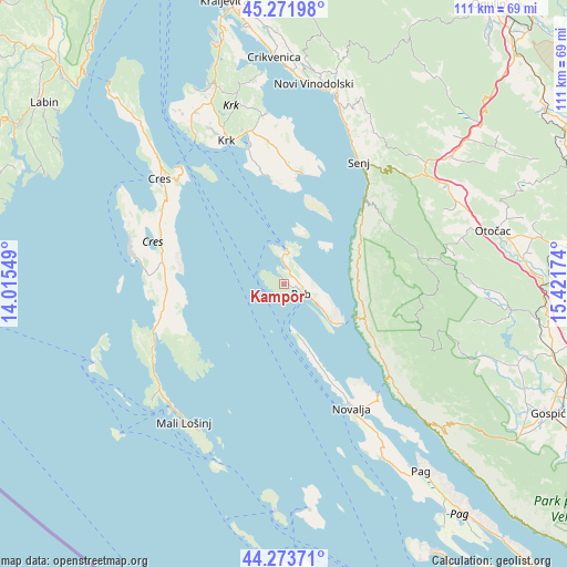
Kampor GPS coordinates[2]
44° 46' 30" North, 14° 43' 6.996" East
| Map corner | latitude | longitude |
|---|---|---|
| Upper-left | 45.27198°, | 14.01549° |
| Center: | 44.775°, | 14.71861° |
| Lower-right: | 44.27371°, | 15.42174° |
| Map W x H: | 111×111 km | = 69×69mi |
| max Lat: | 46.52694° ⇑78.2% North |
| Kampor: | 44.775° |
| min Lat: | ⇓21.8% South 42.54972° |
| min Long | Kampor | max Long |
| 13.52389° | 14.71861° | 19.37694° |
| W 9.2%⇐ | ⇒90.8% E |
Elevation
Elevation of Kampor is 54 m = 177 ft, and this is 99.3 m = 326 ft below average elevation for this country.
| Max E: |
827 m = 2713 ft | 86.5% |
| Avg. | 153.3 m = 503 ft | |
| Kampor | 54 m = 177 ft | |
Min E: |
-1 m = -3 ft | 13.5% |
See also: Croatia elevation on elevation.city.
Geographical zone
Kampor is located in North temperate zone (between Tropic of Cancer and the Arctic Circle). Distance of this Northern Tropic circle is 2372.6 km =1474.3 mi to South.| Distance of | km | miles | from Kampor |
|---|---|---|---|
| North Pole | 5028.5 | 3124.6 | to North |
| Arctic Circle | 2422.7 | 1505.4 | to North |
| Tropic Cancer | 2372.6 | 1474.3 | to South |
| Equator | 4978.5 | 3093.5 | to South |


Nearby cities:
15 places around Kampor: (largest is in red/bold)
• Banjol
5.8 km =3.6 mi,  118°
118°
• Baška
21.9 km =13.6 mi,  7°
7°
• Cres
31.8 km =19.8 mi,  310°
310°
• Krk
30.2 km =18.8 mi,  338°
338°
• Kuterevo
33.8 km =21 mi,  80°
80°
• Lopar
6.5 km =4 mi, 8°
• Mali Lošinj
33.6 km =20.9 mi,  216°
216°
• Mundanije
3.5 km =2.2 mi,  97°
97°
• Novalja
27.6 km =17.1 mi,  151°
151°
• Punat
27.6 km =17.1 mi,  345°
345°
• Rab
3.9 km =2.4 mi, 121°
• Senj
28 km =17.4 mi,  31°
31°
• Supetarska Draga
2.5 km =1.6 mi, 10°
• Veli Lošinj
33.3 km =20.7 mi,  210°
210°
• Vrbnik
33.6 km =20.9 mi, 353°
Sources, notices
• [Note1] Compared only with cities in Croatia existing in our database
• [Src1] Map data: © OpenStreetMap contributors (CC-BY-SA)
• [Src2] Other city data from geonames.org with taken over terms of usage.
• [Src3] Geographical zone / Annual Mean Temperature by Robert A. Rohde @ Wikipedia
