Jérémie geodata
Jérémie (GrandʼAnse) is a seat of a first-order administrative division; located in Haiti in America/Port-au-Prince (GMT-4) time zone. With population of 97,503 people, there are 11 cities with bigger population in this country. Compared to other cities in Haiti, 56.6% of cities are located further ↑North; 92.5% of cities are located further →East and 78.3% of cities have higher elevation than Jérémie. Note1


Jérémie GPS coordinates[2]
18° 39' 0" North, 74° 7' 0.012" West
| Map corner | latitude | longitude |
|---|---|---|
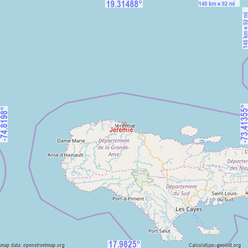
| Upper-left | 19.31488°, | -74.8198° |
| Center: | 18.65°, | -74.11667° |
| Lower-right: | 17.9825°, | -73.41355° |
| Map W x H: | 148.1×148.1 km | = 92×92mi |
| max Lat: | 19.93984° ⇑56.6% North |
| Jérémie: | 18.65° |
| min Lat: | ⇓43.4% South 18.05° |
| min Long | Jérémie | max Long |
| -74.4528° | -74.11667° | -71.72475° |
| W 7.5%⇐ | ⇒92.5% E |
Elevation
Elevation of Jérémie is 12 m = 39 ft, and this is 133.1 m = 437 ft below average elevation for this country.
| Max E: |
1466 m = 4810 ft | 78.3% |
| Avg. | 145.1 m = 476 ft | |
| Jérémie | 12 m = 39 ft | |
Min E: |
3 m = 10 ft | 21.7% |
See also: Jérémie elevation on elevation.city.
Geographical zone
Jérémie is located in North Torrid zone (between Equator and Tropic of Cancer). Distance of this Northern Tropic circle is 532.2 km =330.7 mi to North.| Distance of | km | miles | from Jérémie |
|---|---|---|---|
| North Pole | 7933.4 | 4929.6 | to North |
| Arctic Circle | 5327.5 | 3310.4 | to North |
| Tropic Cancer | 532.2 | 330.7 | to North |
| Equator | 2073.7 | 1288.5 | to South |


Nearby cities:
15 places around Jérémie: (largest is in red/bold)
• Baradères
53.7 km =33.4 mi,  110°
110°
• Camp Perrin
44.6 km =27.7 mi,  143°
143°
• Chambellan
23.5 km =14.6 mi,  241°
241°
• Chantal
55.3 km =34.4 mi,  154°
154°
• Chardonnière
42 km =26.1 mi,  187°
187°
• Corail
25.6 km =15.9 mi, 110°
• Dame-Marie
33.6 km =20.9 mi,  252°
252°
• Koto
50 km =31.1 mi,  170°
170°
• Les Abricots
20.1 km =12.5 mi,  269°
269°
• Les Anglais
39.8 km =24.7 mi,  195°
195°
• Les Irois
44.7 km =27.8 mi,  232°
232°
• Moron
17.9 km =11.1 mi, 236°
• Port-à-Piment
44.6 km =27.7 mi,  177°
177°
• Roche-à-Bateau
53.4 km =33.2 mi, 167°
• Tiburon
46.5 km =28.9 mi,  219°
219°
Sources, notices
• [Note1] Compared only with cities in Haiti existing in our database
• [Src1] Map data: © OpenStreetMap contributors (CC-BY-SA)
• [Src2] Other city data from geonames.org with taken over terms of usage.
• [Src3] Geographical zone / Annual Mean Temperature by Robert A. Rohde @ Wikipedia
