Üröm geodata
Üröm (Pest) is a populated place; located in Hungary in Europe/Budapest (GMT+2) time zone. With population of 4,753 people, there are 313 cities with bigger population in this country. Compared to other cities in Hungary, 62.2% of cities are located further ↓South; 63.4% of cities are located further →East and 88% of cities have lower elevation than Üröm. Note1


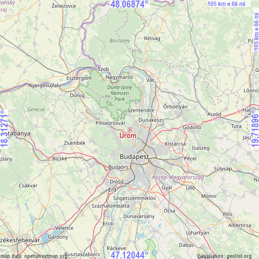
Üröm GPS coordinates[2]
47° 35' 48.264" North, 19° 0' 56.988" East
| Map corner | latitude | longitude |
|---|---|---|
| Upper-left | 48.06874°, | 18.31271° |
| Center: | 47.59674°, | 19.01583° |
| Lower-right: | 47.12044°, | 19.71896° |
| Map W x H: | 105.4×105.4 km | = 65.5×65.5mi |
| max Lat: | 48.46667° ⇑37.8% North |
| Üröm: | 47.59674° |
| min Lat: | ⇓62.2% South 45.79108° |
| min Long | Üröm | max Long |
| 16.27358° | 19.01583° | 22.68096° |
| W 36.6%⇐ | ⇒63.4% E |
Elevation
Elevation of Üröm is 181 m = 594 ft, and this is 51.3 m = 168 ft above average elevation for this country.
| Max E: |
444 m = 1457 ft | 12% |
| Üröm | 181 m 594 ft | |
| Avg. | 129.7 m = 426 ft | |
Min E: |
71 m = 233 ft | 88% |
See also: Hungary elevation on elevation.city.
Geographical zone
Üröm is located in North temperate zone (between Tropic of Cancer and the Arctic Circle). Distance of this North polar circle is 2108.9 km =1310.4 mi to North.| Distance of | km | miles | from Üröm |
|---|---|---|---|
| North Pole | 4714.8 | 2929.6 | to North |
| Arctic Circle | 2108.9 | 1310.4 | to North |
| Tropic Cancer | 2686.3 | 1669.2 | to South |
| Equator | 5292.3 | 3288.5 | to South |


Nearby cities:
15 places around Üröm: (largest is in red/bold)
• Budakalász
3.4 km =2.1 mi,  49°
49°
• Budapest II. kerület
8.6 km =5.3 mi,  176°
176°
• Budapest III. kerület
6.5 km =4 mi,  160°
160°
• Budapest IV. kerület
6.7 km =4.2 mi,  125°
125°
• Budapest XIII. kerület
8.9 km =5.5 mi,  146°
146°
• Budapest XV. kerület
8.5 km =5.3 mi,  116°
116°
• Csobánka
6.8 km =4.2 mi,  323°
323°
• Nagykovácsi
5.9 km =3.7 mi,  0°
0°
• Pilisborosjenő
2.1 km =1.3 mi,  305°
305°
• Pilisszentiván
8.8 km =5.5 mi,  279°
279°
• Pilisvörösvár
8.2 km =5.1 mi, 283°
• Pomáz
5.1 km =3.2 mi,  10°
10°
• Remeteszőlős
8.3 km =5.2 mi,  240°
240°
• Solymár
6.3 km =3.9 mi,  265°
265°
• Szentendre
9.2 km =5.7 mi,  28°
28°
Sources, notices
• [Note1] Compared only with cities in Hungary existing in our database
• [Src1] Map data: © OpenStreetMap contributors (CC-BY-SA)
• [Src2] Other city data from geonames.org with taken over terms of usage.
• [Src3] Geographical zone / Annual Mean Temperature by Robert A. Rohde @ Wikipedia
