Csobánka geodata
Csobánka (Pest) is a populated place; located in Hungary in Europe/Budapest (GMT+2) time zone. With population of 2,881 people, there are 520 cities with bigger population in this country. Compared to other cities in Hungary, 66.6% of cities are located further ↓South; 65.9% of cities are located further →East and 85% of cities have lower elevation than Csobánka. Note1


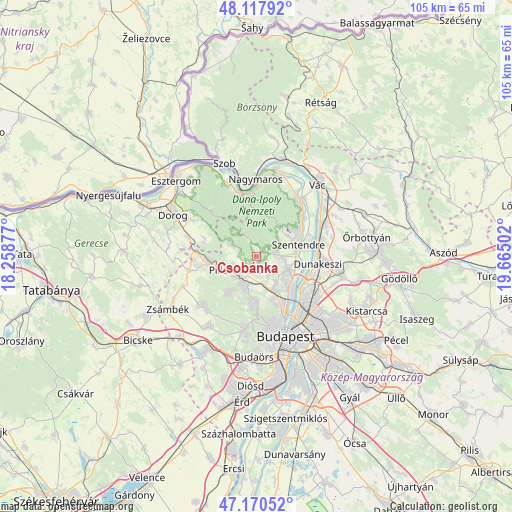
Csobánka GPS coordinates[2]
47° 38' 46.932" North, 18° 57' 42.804" East
| Map corner | latitude | longitude |
|---|---|---|
| Upper-left | 48.11792°, | 18.25877° |
| Center: | 47.64637°, | 18.96189° |
| Lower-right: | 47.17052°, | 19.66502° |
| Map W x H: | 105.3×105.3 km | = 65.4×65.4mi |
| max Lat: | 48.46667° ⇑33.4% North |
| Csobánka: | 47.64637° |
| min Lat: | ⇓66.6% South 45.79108° |
| min Long | Csobánka | max Long |
| 16.27358° | 18.96189° | 22.68096° |
| W 34.1%⇐ | ⇒65.9% E |
Elevation
Elevation of Csobánka is 173 m = 568 ft, and this is 43.3 m = 142 ft above average elevation for this country.
| Max E: |
444 m = 1457 ft | 15% |
| Csobánka | 173 m 568 ft | |
| Avg. | 129.7 m = 426 ft | |
Min E: |
71 m = 233 ft | 85% |
See also: Hungary elevation on elevation.city.
Geographical zone
Csobánka is located in North temperate zone (between Tropic of Cancer and the Arctic Circle). Distance of this North polar circle is 2103.4 km =1307 mi to North.| Distance of | km | miles | from Csobánka |
|---|---|---|---|
| North Pole | 4709.3 | 2926.2 | to North |
| Arctic Circle | 2103.4 | 1307 | to North |
| Tropic Cancer | 2691.9 | 1672.7 | to South |
| Equator | 5297.8 | 3291.9 | to South |


Nearby cities:
15 places around Csobánka: (largest is in red/bold)
• Budakalász
7.4 km =4.6 mi,  116°
116°
• Leányfalu
12.2 km =7.6 mi,  49°
49°
• Nagykovácsi
4.1 km =2.5 mi,  84°
84°
• Pilisborosjenő
4.9 km =3 mi,  151°
151°
• Piliscsaba
10.1 km =6.3 mi,  262°
262°
• Piliscsév
11.3 km =7 mi,  288°
288°
• Pilisszentiván
6.2 km =3.9 mi,  228°
228°
• Pilisszentkereszt
6.6 km =4.1 mi,  319°
319°
• Pilisszántó
6.1 km =3.8 mi, 294°
• Pilisvörösvár
5.4 km =3.4 mi, 227°
• Pomáz
5 km =3.1 mi,  95°
95°
• Remeteszőlős
10.1 km =6.3 mi,  198°
198°
• Solymár
6.4 km =4 mi, 200°
• Szentendre
8.9 km =5.5 mi,  73°
73°
• Üröm
6.8 km =4.2 mi,  143°
143°
Sources, notices
• [Note1] Compared only with cities in Hungary existing in our database
• [Src1] Map data: © OpenStreetMap contributors (CC-BY-SA)
• [Src2] Other city data from geonames.org with taken over terms of usage.
• [Src3] Geographical zone / Annual Mean Temperature by Robert A. Rohde @ Wikipedia
