Solymár geodata
Solymár (Pest) is a populated place; located in Hungary in Europe/Budapest (GMT+2) time zone. With population of 9,242 people, there are 176 cities with bigger population in this country. Compared to other cities in Hungary, 61.9% of cities are located further ↓South; 67.3% of cities are located further →East and 90.8% of cities have lower elevation than Solymár. Note1


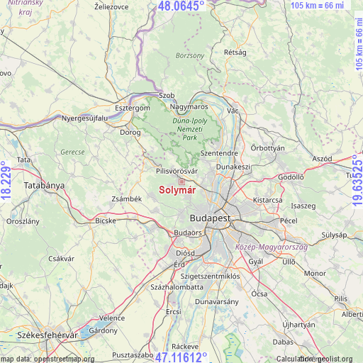
Solymár GPS coordinates[2]
47° 35' 32.856" North, 18° 55' 55.632" East
| Map corner | latitude | longitude |
|---|---|---|
| Upper-left | 48.0645°, | 18.229° |
| Center: | 47.59246°, | 18.93212° |
| Lower-right: | 47.11612°, | 19.63525° |
| Map W x H: | 105.4×105.4 km | = 65.5×65.5mi |
| max Lat: | 48.46667° ⇑38.1% North |
| Solymár: | 47.59246° |
| min Lat: | ⇓61.9% South 45.79108° |
| min Long | Solymár | max Long |
| 16.27358° | 18.93212° | 22.68096° |
| W 32.7%⇐ | ⇒67.3% E |
Elevation
Elevation of Solymár is 193 m = 633 ft, and this is 63.3 m = 208 ft above average elevation for this country.
| Max E: |
444 m = 1457 ft | 9.2% |
| Solymár | 193 m 633 ft | |
| Avg. | 129.7 m = 426 ft | |
Min E: |
71 m = 233 ft | 90.8% |
See also: Hungary elevation on elevation.city.
Geographical zone
Solymár is located in North temperate zone (between Tropic of Cancer and the Arctic Circle). Distance of this North polar circle is 2109.4 km =1310.7 mi to North.| Distance of | km | miles | from Solymár |
|---|---|---|---|
| North Pole | 4715.3 | 2930 | to North |
| Arctic Circle | 2109.4 | 1310.7 | to North |
| Tropic Cancer | 2685.9 | 1668.9 | to South |
| Equator | 5291.8 | 3288.2 | to South |


Nearby cities:
15 places around Solymár: (largest is in red/bold)
• Budakalász
9.2 km =5.7 mi,  73°
73°
• Budakeszi
9.1 km =5.7 mi,  182°
182°
• Budapest II. kerület
10.5 km =6.5 mi,  140°
140°
• Budapest III. kerület
10.2 km =6.3 mi,  123°
123°
• Csobánka
6.4 km =4 mi,  20°
20°
• Nagykovácsi
9 km =5.6 mi,  44°
44°
• Pilisborosjenő
4.9 km =3 mi, 70°
• Piliscsaba
9 km =5.6 mi,  300°
300°
• Pilisszentiván
3.1 km =1.9 mi,  307°
307°
• Pilisszántó
9.1 km =5.7 mi,  338°
338°
• Pilisvörösvár
2.9 km =1.8 mi,  323°
323°
• Pomáz
9.1 km =5.7 mi,  52°
52°
• Remeteszőlős
3.7 km =2.3 mi,  194°
194°
• Telki
9.2 km =5.7 mi,  237°
237°
• Üröm
6.3 km =3.9 mi,  85°
85°
Sources, notices
• [Note1] Compared only with cities in Hungary existing in our database
• [Src1] Map data: © OpenStreetMap contributors (CC-BY-SA)
• [Src2] Other city data from geonames.org with taken over terms of usage.
• [Src3] Geographical zone / Annual Mean Temperature by Robert A. Rohde @ Wikipedia
