Szentendre geodata
Szentendre (Pest) is a populated place; located in Hungary in Europe/Budapest (GMT+2) time zone. With population of 23,606 people, there are 71 cities with bigger population in this country. Compared to other cities in Hungary, 68.1% of cities are located further ↓South; 60.6% of cities are located further →East and 53.5% of cities have lower elevation than Szentendre. Note1


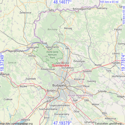
Szentendre GPS coordinates[2]
47° 40' 9.948" North, 19° 4' 32.196" East
| Map corner | latitude | longitude |
|---|---|---|
| Upper-left | 48.14077°, | 18.37249° |
| Center: | 47.66943°, | 19.07561° |
| Lower-right: | 47.19379°, | 19.77874° |
| Map W x H: | 105.3×105.3 km | = 65.4×65.4mi |
| max Lat: | 48.46667° ⇑31.9% North |
| Szentendre: | 47.66943° |
| min Lat: | ⇓68.1% South 45.79108° |
| min Long | Szentendre | max Long |
| 16.27358° | 19.07561° | 22.68096° |
| W 39.4%⇐ | ⇒60.6% E |
Elevation
Elevation of Szentendre is 119 m = 390 ft, and this is 10.7 m = 35 ft below average elevation for this country.
| Max E: |
444 m = 1457 ft | 46.5% |
| Avg. | 129.7 m = 426 ft | |
| Szentendre | 119 m = 390 ft | |
Min E: |
71 m = 233 ft | 53.5% |
See also: Hungary elevation on elevation.city.
Geographical zone
Szentendre is located in North temperate zone (between Tropic of Cancer and the Arctic Circle). Distance of this North polar circle is 2100.8 km =1305.4 mi to North.| Distance of | km | miles | from Szentendre |
|---|---|---|---|
| North Pole | 4706.7 | 2924.6 | to North |
| Arctic Circle | 2100.8 | 1305.4 | to North |
| Tropic Cancer | 2694.4 | 1674.2 | to South |
| Equator | 5300.3 | 3293.5 | to South |


Nearby cities:
15 places around Szentendre: (largest is in red/bold)
• Budakalász
6.2 km =3.9 mi,  198°
198°
• Budapest IV. kerület
12 km =7.5 mi,  175°
175°
• Budapest XV. kerület
12.3 km =7.6 mi,  165°
165°
• Csobánka
8.9 km =5.5 mi,  253°
253°
• Dunakeszi
6 km =3.7 mi,  127°
127°
• Fót
10.2 km =6.3 mi,  124°
124°
• Göd
4.6 km =2.9 mi,  70°
70°
• Leányfalu
5.4 km =3.4 mi,  8°
8°
• Nagykovácsi
4.9 km =3 mi,  243°
243°
• Pilisborosjenő
9.3 km =5.8 mi,  221°
221°
• Pomáz
4.7 km =2.9 mi,  229°
229°
• Sződ
9.4 km =5.8 mi,  49°
49°
• Sződliget
8.8 km =5.5 mi,  37°
37°
• Tahitótfalu
9.1 km =5.7 mi, 11°
• Üröm
9.2 km =5.7 mi,  208°
208°
Sources, notices
• [Note1] Compared only with cities in Hungary existing in our database
• [Src1] Map data: © OpenStreetMap contributors (CC-BY-SA)
• [Src2] Other city data from geonames.org with taken over terms of usage.
• [Src3] Geographical zone / Annual Mean Temperature by Robert A. Rohde @ Wikipedia
