Tata geodata
Tata (Komárom-Esztergom) is a seat of a second-order administrative division; located in Hungary in Europe/Budapest (GMT+2) time zone. With population of 23,868 people, there are 70 cities with bigger population in this country. Compared to other cities in Hungary, 67.2% of cities are located further ↓South; 80.5% of cities are located further →East and 56.8% of cities have lower elevation than Tata. Note1


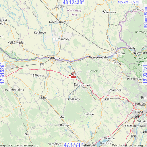
Tata GPS coordinates[2]
47° 39' 10.404" North, 18° 19' 6.168" East
| Map corner | latitude | longitude |
|---|---|---|
| Upper-left | 48.12438°, | 17.61526° |
| Center: | 47.65289°, | 18.31838° |
| Lower-right: | 47.1771°, | 19.02151° |
| Map W x H: | 105.3×105.3 km | = 65.4×65.4mi |
| max Lat: | 48.46667° ⇑32.8% North |
| Tata: | 47.65289° |
| min Lat: | ⇓67.2% South 45.79108° |
| min Long | Tata | max Long |
| 16.27358° | 18.31838° | 22.68096° |
| W 19.5%⇐ | ⇒80.5% E |
Elevation
Elevation of Tata is 123 m = 404 ft, and this is 6.7 m = 22 ft below average elevation for this country.
| Max E: |
444 m = 1457 ft | 43.2% |
| Avg. | 129.7 m = 426 ft | |
| Tata | 123 m = 404 ft | |
Min E: |
71 m = 233 ft | 56.8% |
See also: Hungary elevation on elevation.city.
Geographical zone
Tata is located in North temperate zone (between Tropic of Cancer and the Arctic Circle). Distance of this North polar circle is 2102.7 km =1306.6 mi to North.| Distance of | km | miles | from Tata |
|---|---|---|---|
| North Pole | 4708.6 | 2925.8 | to North |
| Arctic Circle | 2102.7 | 1306.6 | to North |
| Tropic Cancer | 2692.6 | 1673.1 | to South |
| Equator | 5298.5 | 3292.3 | to South |


Nearby cities:
15 places around Tata: (largest is in red/bold)
• Almásfüzitő
9.3 km =5.8 mi,  332°
332°
• Baj
3.5 km =2.2 mi,  102°
102°
• Dunaalmás
8.4 km =5.2 mi,  2°
2°
• Kecskéd
14.5 km =9 mi,  182°
182°
• Kocs
9.2 km =5.7 mi,  236°
236°
• Környe
11.8 km =7.3 mi, 179°
• Mocsa
10.2 km =6.3 mi,  280°
280°
• Naszály
7.2 km =4.5 mi,  320°
320°
• Neszmély
9.7 km =6 mi,  18°
18°
• Szomód
3.9 km =2.4 mi,  25°
25°
• Süttő
15.3 km =9.5 mi,  39°
39°
• Tardos
9.5 km =5.9 mi,  83°
83°
• Tarján
15.2 km =9.4 mi,  108°
108°
• Tatabánya
9.4 km =5.8 mi,  143°
143°
• Vértesszőlős
5.9 km =3.7 mi,  126°
126°
Sources, notices
• [Note1] Compared only with cities in Hungary existing in our database
• [Src1] Map data: © OpenStreetMap contributors (CC-BY-SA)
• [Src2] Other city data from geonames.org with taken over terms of usage.
• [Src3] Geographical zone / Annual Mean Temperature by Robert A. Rohde @ Wikipedia
