Környe geodata
Környe (Komárom-Esztergom) is a populated place; located in Hungary in Europe/Budapest (GMT+2) time zone. With population of 4,359 people, there are 342 cities with bigger population in this country. Compared to other cities in Hungary, 58.8% of cities are located further ↓South; 80.4% of cities are located further →East and 82.3% of cities have lower elevation than Környe. Note1


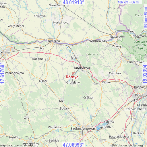
Környe GPS coordinates[2]
47° 32' 48.048" North, 18° 19' 14.916" East
| Map corner | latitude | longitude |
|---|---|---|
| Upper-left | 48.01913°, | 17.61769° |
| Center: | 47.54668°, | 18.32081° |
| Lower-right: | 47.06993°, | 19.02394° |
| Map W x H: | 105.5×105.5 km | = 65.6×65.6mi |
| max Lat: | 48.46667° ⇑41.2% North |
| Környe: | 47.54668° |
| min Lat: | ⇓58.8% South 45.79108° |
| min Long | Környe | max Long |
| 16.27358° | 18.32081° | 22.68096° |
| W 19.6%⇐ | ⇒80.4% E |
Elevation
Elevation of Környe is 164 m = 538 ft, and this is 34.3 m = 113 ft above average elevation for this country.
| Max E: |
444 m = 1457 ft | 17.7% |
| Környe | 164 m 538 ft | |
| Avg. | 129.7 m = 426 ft | |
Min E: |
71 m = 233 ft | 82.3% |
See also: Hungary elevation on elevation.city.
Geographical zone
Környe is located in North temperate zone (between Tropic of Cancer and the Arctic Circle). Distance of this North polar circle is 2114.5 km =1313.9 mi to North.| Distance of | km | miles | from Környe |
|---|---|---|---|
| North Pole | 4720.4 | 2933.1 | to North |
| Arctic Circle | 2114.5 | 1313.9 | to North |
| Tropic Cancer | 2680.8 | 1665.8 | to South |
| Equator | 5286.7 | 3285 | to South |


Nearby cities:
15 places around Környe: (largest is in red/bold)
• Baj
11.5 km =7.1 mi,  16°
16°
• Bokod
8.2 km =5.1 mi,  222°
222°
• Császár
14.4 km =8.9 mi,  247°
247°
• Kecskéd
2.8 km =1.7 mi,  198°
198°
• Kocs
10.4 km =6.5 mi,  310°
310°
• Mocsa
17.1 km =10.6 mi,  323°
323°
• Oroszlány
6.7 km =4.2 mi,  185°
185°
• Pusztavám
14.8 km =9.2 mi,  208°
208°
• Szomód
15.4 km =9.6 mi,  5°
5°
• Szárliget
13.5 km =8.4 mi,  104°
104°
• Tardos
15.8 km =9.8 mi,  35°
35°
• Tarján
15.9 km =9.9 mi,  63°
63°
• Tata
11.8 km =7.3 mi,  359°
359°
• Tatabánya
6.9 km =4.3 mi,  51°
51°
• Vértesszőlős
9.4 km =5.8 mi,  28°
28°
Sources, notices
• [Note1] Compared only with cities in Hungary existing in our database
• [Src1] Map data: © OpenStreetMap contributors (CC-BY-SA)
• [Src2] Other city data from geonames.org with taken over terms of usage.
• [Src3] Geographical zone / Annual Mean Temperature by Robert A. Rohde @ Wikipedia
