Tarján geodata
Tarján (Komárom-Esztergom) is a populated place; located in Hungary in Europe/Budapest (GMT+2) time zone. With population of 2,825 people, there are 534 cities with bigger population in this country. Compared to other cities in Hungary, 63.6% of cities are located further ↓South; 76.6% of cities are located further →East and 91.3% of cities have lower elevation than Tarján. Note1


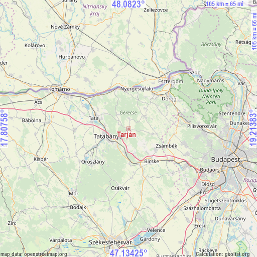
Tarján GPS coordinates[2]
47° 36' 37.512" North, 18° 30' 38.52" East
| Map corner | latitude | longitude |
|---|---|---|
| Upper-left | 48.0823°, | 17.80758° |
| Center: | 47.61042°, | 18.5107° |
| Lower-right: | 47.13425°, | 19.21383° |
| Map W x H: | 105.4×105.4 km | = 65.5×65.5mi |
| max Lat: | 48.46667° ⇑36.4% North |
| Tarján: | 47.61042° |
| min Lat: | ⇓63.6% South 45.79108° |
| min Long | Tarján | max Long |
| 16.27358° | 18.5107° | 22.68096° |
| W 23.4%⇐ | ⇒76.6% E |
Elevation
Elevation of Tarján is 194 m = 636 ft, and this is 64.3 m = 211 ft above average elevation for this country.
| Max E: |
444 m = 1457 ft | 8.7% |
| Tarján | 194 m 636 ft | |
| Avg. | 129.7 m = 426 ft | |
Min E: |
71 m = 233 ft | 91.3% |
See also: Hungary elevation on elevation.city.
Geographical zone
Tarján is located in North temperate zone (between Tropic of Cancer and the Arctic Circle). Distance of this North polar circle is 2107.4 km =1309.5 mi to North.| Distance of | km | miles | from Tarján |
|---|---|---|---|
| North Pole | 4713.3 | 2928.7 | to North |
| Arctic Circle | 2107.4 | 1309.5 | to North |
| Tropic Cancer | 2687.9 | 1670.2 | to South |
| Equator | 5293.8 | 3289.4 | to South |


Nearby cities:
15 places around Tarján: (largest is in red/bold)
• Baj
11.7 km =7.3 mi,  289°
289°
• Bajna
8.1 km =5 mi,  53°
53°
• Környe
15.9 km =9.9 mi,  243°
243°
• Lábatlan
15.3 km =9.5 mi,  355°
355°
• Mány
13.9 km =8.6 mi,  128°
128°
• Nyergesújfalu
17 km =10.6 mi,  11°
11°
• Szomód
15.2 km =9.4 mi,  303°
303°
• Szárliget
10.6 km =6.6 mi,  186°
186°
• Sárisáp
14.6 km =9.1 mi,  59°
59°
• Süttő
17.1 km =10.6 mi,  344°
344°
• Tardos
7.6 km =4.7 mi,  318°
318°
• Tata
15.2 km =9.4 mi, 288°
• Tatabánya
9.3 km =5.8 mi,  252°
252°
• Tokod
16.7 km =10.4 mi,  41°
41°
• Vértesszőlős
9.8 km =6.1 mi,  276°
276°
Sources, notices
• [Note1] Compared only with cities in Hungary existing in our database
• [Src1] Map data: © OpenStreetMap contributors (CC-BY-SA)
• [Src2] Other city data from geonames.org with taken over terms of usage.
• [Src3] Geographical zone / Annual Mean Temperature by Robert A. Rohde @ Wikipedia
