Kocs geodata
Kocs (Komárom-Esztergom) is a populated place; located in Hungary in Europe/Budapest (GMT+2) time zone. With population of 2,655 people, there are 579 cities with bigger population in this country. Compared to other cities in Hungary, 63.3% of cities are located further ↓South; 82.9% of cities are located further →East and 72.6% of cities have lower elevation than Kocs. Note1


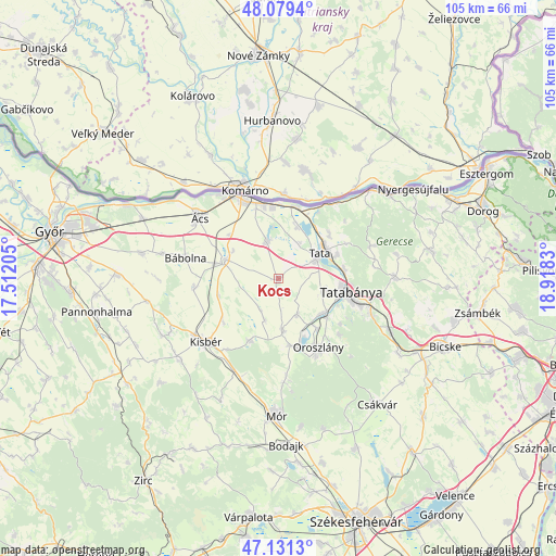
Kocs GPS coordinates[2]
47° 36' 27" North, 18° 12' 54.612" East
| Map corner | latitude | longitude |
|---|---|---|
| Upper-left | 48.0794°, | 17.51205° |
| Center: | 47.6075°, | 18.21517° |
| Lower-right: | 47.1313°, | 18.9183° |
| Map W x H: | 105.4×105.4 km | = 65.5×65.5mi |
| max Lat: | 48.46667° ⇑36.7% North |
| Kocs: | 47.6075° |
| min Lat: | ⇓63.3% South 45.79108° |
| min Long | Kocs | max Long |
| 16.27358° | 18.21517° | 22.68096° |
| W 17.1%⇐ | ⇒82.9% E |
Elevation
Elevation of Kocs is 141 m = 463 ft, and this is 11.3 m = 37 ft above average elevation for this country.
| Max E: |
444 m = 1457 ft | 27.4% |
| Kocs | 141 m 463 ft | |
| Avg. | 129.7 m = 426 ft | |
Min E: |
71 m = 233 ft | 72.6% |
See also: Hungary elevation on elevation.city.
Geographical zone
Kocs is located in North temperate zone (between Tropic of Cancer and the Arctic Circle). Distance of this North polar circle is 2107.7 km =1309.7 mi to North.| Distance of | km | miles | from Kocs |
|---|---|---|---|
| North Pole | 4713.6 | 2928.9 | to North |
| Arctic Circle | 2107.7 | 1309.7 | to North |
| Tropic Cancer | 2687.5 | 1669.9 | to South |
| Equator | 5293.5 | 3289.2 | to South |


Nearby cities:
15 places around Kocs: (largest is in red/bold)
• Almásfüzitő
13.8 km =8.6 mi,  14°
14°
• Baj
12 km =7.5 mi,  69°
69°
• Bokod
13.1 km =8.1 mi,  169°
169°
• Császár
13.3 km =8.3 mi,  204°
204°
• Ete
13.5 km =8.4 mi,  230°
230°
• Kecskéd
11.8 km =7.3 mi,  143°
143°
• Környe
10.4 km =6.5 mi,  130°
130°
• Mocsa
7.3 km =4.5 mi,  342°
342°
• Nagyigmánd
10.7 km =6.6 mi,  290°
290°
• Naszály
11.1 km =6.9 mi,  16°
16°
• Oroszlány
15.3 km =9.5 mi,  151°
151°
• Szomód
12.7 km =7.9 mi,  47°
47°
• Tata
9.2 km =5.7 mi,  56°
56°
• Tatabánya
13.6 km =8.5 mi,  100°
100°
• Vértesszőlős
12.5 km =7.8 mi,  83°
83°
Sources, notices
• [Note1] Compared only with cities in Hungary existing in our database
• [Src1] Map data: © OpenStreetMap contributors (CC-BY-SA)
• [Src2] Other city data from geonames.org with taken over terms of usage.
• [Src3] Geographical zone / Annual Mean Temperature by Robert A. Rohde @ Wikipedia
