Tápiószőlős geodata
Tápiószőlős (Pest) is a populated place; located in Hungary in Europe/Budapest (GMT+2) time zone. With population of 3,155 people, there are 468 cities with bigger population in this country. Compared to other cities in Hungary, 56.5% of cities are located further ↑North; 58.4% of cities are located further ←West and 78.9% of cities have higher elevation than Tápiószőlős. Note1


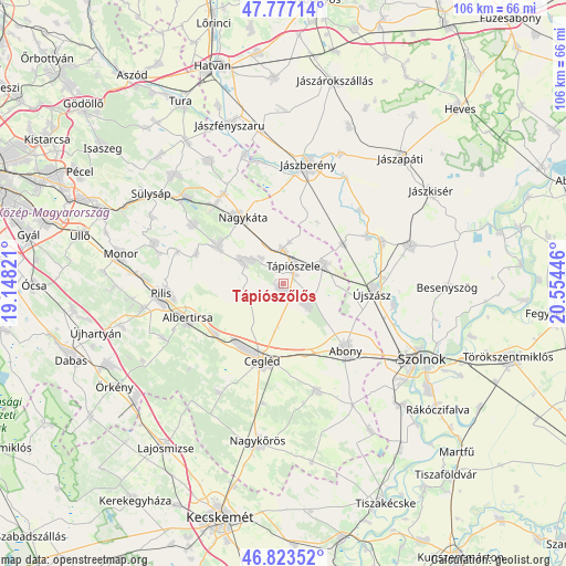
Tápiószőlős GPS coordinates[2]
47° 18' 8.928" North, 19° 51' 4.788" East
| Map corner | latitude | longitude |
|---|---|---|
| Upper-left | 47.77714°, | 19.14821° |
| Center: | 47.30248°, | 19.85133° |
| Lower-right: | 46.82352°, | 20.55446° |
| Map W x H: | 106×106 km | = 65.9×65.9mi |
| max Lat: | 48.46667° ⇑56.5% North |
| Tápiószőlős: | 47.30248° |
| min Lat: | ⇓43.5% South 45.79108° |
| min Long | Tápiószőlős | max Long |
| 16.27358° | 19.85133° | 22.68096° |
| W 58.4%⇐ | ⇒41.6% E |
Elevation
Elevation of Tápiószőlős is 96 m = 315 ft, and this is 33.7 m = 111 ft below average elevation for this country.
| Max E: |
444 m = 1457 ft | 78.9% |
| Avg. | 129.7 m = 426 ft | |
| Tápiószőlős | 96 m = 315 ft | |
Min E: |
71 m = 233 ft | 21.1% |
See also: Hungary elevation on elevation.city.
Geographical zone
Tápiószőlős is located in North temperate zone (between Tropic of Cancer and the Arctic Circle). Distance of this North polar circle is 2141.6 km =1330.7 mi to North.| Distance of | km | miles | from Tápiószőlős |
|---|---|---|---|
| North Pole | 4747.5 | 2950 | to North |
| Arctic Circle | 2141.6 | 1330.7 | to North |
| Tropic Cancer | 2653.6 | 1648.9 | to South |
| Equator | 5259.5 | 3268.1 | to South |


Nearby cities:
15 places around Tápiószőlős: (largest is in red/bold)
• Abony
17.1 km =10.6 mi,  137°
137°
• Alattyán
20 km =12.4 mi,  46°
46°
• Albertirsa
18.9 km =11.7 mi,  249°
249°
• Cegléd
15 km =9.3 mi,  195°
195°
• Ceglédbercel
16.4 km =10.2 mi,  237°
237°
• Farmos
6.5 km =4 mi,  356°
356°
• Jánoshida
18.5 km =11.5 mi,  61°
61°
• Nagykáta
14.9 km =9.3 mi,  327°
327°
• Pánd
17.2 km =10.7 mi,  289°
289°
• Tápióbicske
14 km =8.7 mi,  297°
297°
• Tápiógyörgye
8.5 km =5.3 mi, 64°
• Tápiószele
4.2 km =2.6 mi,  27°
27°
• Tápiószentmárton
8.9 km =5.5 mi, 297°
• Újszilvás
6.3 km =3.9 mi,  119°
119°
• Újszász
17.5 km =10.9 mi,  90°
90°
Sources, notices
• [Note1] Compared only with cities in Hungary existing in our database
• [Src1] Map data: © OpenStreetMap contributors (CC-BY-SA)
• [Src2] Other city data from geonames.org with taken over terms of usage.
• [Src3] Geographical zone / Annual Mean Temperature by Robert A. Rohde @ Wikipedia
