Cegléd geodata
Cegléd (Pest) is a seat of a second-order administrative division; located in Hungary in Europe/Budapest (GMT+2) time zone. With population of 39,287 people, there are 45 cities with bigger population in this country. Compared to other cities in Hungary, 62.9% of cities are located further ↑North; 57.4% of cities are located further ←West and 65.5% of cities have higher elevation than Cegléd. Note1


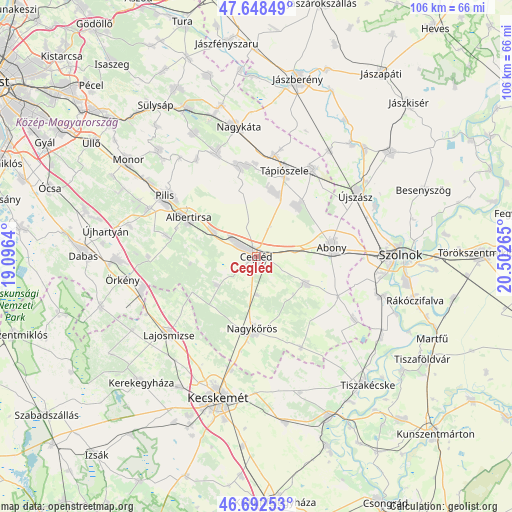
Cegléd GPS coordinates[2]
47° 10' 21.576" North, 19° 47' 58.272" East
| Map corner | latitude | longitude |
|---|---|---|
| Upper-left | 47.64849°, | 19.0964° |
| Center: | 47.17266°, | 19.79952° |
| Lower-right: | 46.69253°, | 20.50265° |
| Map W x H: | 106.3×106.3 km | = 66.1×66.1mi |
| max Lat: | 48.46667° ⇑62.9% North |
| Cegléd: | 47.17266° |
| min Lat: | ⇓37.1% South 45.79108° |
| min Long | Cegléd | max Long |
| 16.27358° | 19.79952° | 22.68096° |
| W 57.4%⇐ | ⇒42.6% E |
Elevation
Elevation of Cegléd is 106 m = 348 ft, and this is 23.7 m = 78 ft below average elevation for this country.
| Max E: |
444 m = 1457 ft | 65.5% |
| Avg. | 129.7 m = 426 ft | |
| Cegléd | 106 m = 348 ft | |
Min E: |
71 m = 233 ft | 34.5% |
See also: Hungary elevation on elevation.city.
Geographical zone
Cegléd is located in North temperate zone (between Tropic of Cancer and the Arctic Circle). Distance of this North polar circle is 2156.1 km =1339.7 mi to North.| Distance of | km | miles | from Cegléd |
|---|---|---|---|
| North Pole | 4762 | 2959 | to North |
| Arctic Circle | 2156.1 | 1339.7 | to North |
| Tropic Cancer | 2639.2 | 1639.9 | to South |
| Equator | 5245.1 | 3259.2 | to South |


Nearby cities:
15 places around Cegléd: (largest is in red/bold)
• Abony
15.6 km =9.7 mi,  82°
82°
• Albertirsa
15.9 km =9.9 mi,  299°
299°
• Ceglédbercel
11.4 km =7.1 mi, 299°
• Csemő
10.2 km =6.3 mi,  233°
233°
• Dánszentmiklós
19.7 km =12.2 mi,  283°
283°
• Farmos
21.2 km =13.2 mi,  9°
9°
• Kocsér
21.1 km =13.1 mi,  154°
154°
• Nagykőrös
15.5 km =9.6 mi,  185°
185°
• Tápióbicske
22.6 km =14 mi,  337°
337°
• Tápiógyörgye
21.4 km =13.3 mi,  32°
32°
• Tápiószele
19.1 km =11.9 mi,  17°
17°
• Tápiószentmárton
19 km =11.8 mi,  347°
347°
• Tápiószőlős
15 km =9.3 mi, 15°
• Törtel
11.8 km =7.3 mi,  118°
118°
• Újszilvás
14.8 km =9.2 mi,  39°
39°
Sources, notices
• [Note1] Compared only with cities in Hungary existing in our database
• [Src1] Map data: © OpenStreetMap contributors (CC-BY-SA)
• [Src2] Other city data from geonames.org with taken over terms of usage.
• [Src3] Geographical zone / Annual Mean Temperature by Robert A. Rohde @ Wikipedia
