Nagykáta geodata
Nagykáta (Pest) is a seat of a second-order administrative division; located in Hungary in Europe/Budapest (GMT+2) time zone. With population of 13,322 people, there are 123 cities with bigger population in this country. Compared to other cities in Hungary, 50.2% of cities are located further ↓South; 55.9% of cities are located further ←West and 56.5% of cities have higher elevation than Nagykáta. Note1


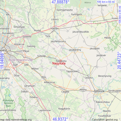
Nagykáta GPS coordinates[2]
47° 24' 54.504" North, 19° 44' 38.76" East
| Map corner | latitude | longitude |
|---|---|---|
| Upper-left | 47.88878°, | 19.04098° |
| Center: | 47.41514°, | 19.7441° |
| Lower-right: | 46.9372°, | 20.44723° |
| Map W x H: | 105.8×105.8 km | = 65.7×65.7mi |
| max Lat: | 48.46667° ⇑49.8% North |
| Nagykáta: | 47.41514° |
| min Lat: | ⇓50.2% South 45.79108° |
| min Long | Nagykáta | max Long |
| 16.27358° | 19.7441° | 22.68096° |
| W 55.9%⇐ | ⇒44.1% E |
Elevation
Elevation of Nagykáta is 112 m = 367 ft, and this is 17.7 m = 58 ft below average elevation for this country.
| Max E: |
444 m = 1457 ft | 56.5% |
| Avg. | 129.7 m = 426 ft | |
| Nagykáta | 112 m = 367 ft | |
Min E: |
71 m = 233 ft | 43.5% |
See also: Hungary elevation on elevation.city.
Geographical zone
Nagykáta is located in North temperate zone (between Tropic of Cancer and the Arctic Circle). Distance of this North polar circle is 2129.1 km =1323 mi to North.| Distance of | km | miles | from Nagykáta |
|---|---|---|---|
| North Pole | 4735 | 2942.2 | to North |
| Arctic Circle | 2129.1 | 1323 | to North |
| Tropic Cancer | 2666.2 | 1656.7 | to South |
| Equator | 5272.1 | 3275.9 | to South |


Nearby cities:
15 places around Nagykáta: (largest is in red/bold)
• Farmos
9.8 km =6.1 mi,  128°
128°
• Forrópuszta
7.7 km =4.8 mi,  305°
305°
• Jászberény
16 km =9.9 mi,  53°
53°
• Kóka
14.7 km =9.1 mi,  302°
302°
• Pánd
10.7 km =6.6 mi,  229°
229°
• Szentlőrinckáta
11.6 km =7.2 mi,  3°
3°
• Szentmártonkáta
5.4 km =3.4 mi,  323°
323°
• Tápióbicske
7.4 km =4.6 mi,  215°
215°
• Tápiószecső
10.9 km =6.8 mi,  290°
290°
• Tápiószele
13.3 km =8.3 mi, 131°
• Tápiószentmárton
8.4 km =5.2 mi,  178°
178°
• Tápiószőlős
14.9 km =9.3 mi,  147°
147°
• Tápióság
8.7 km =5.4 mi,  260°
260°
• Tóalmás
11.8 km =7.3 mi,  330°
330°
• Úri
16.3 km =10.1 mi,  269°
269°
Sources, notices
• [Note1] Compared only with cities in Hungary existing in our database
• [Src1] Map data: © OpenStreetMap contributors (CC-BY-SA)
• [Src2] Other city data from geonames.org with taken over terms of usage.
• [Src3] Geographical zone / Annual Mean Temperature by Robert A. Rohde @ Wikipedia
