Albertirsa geodata
Albertirsa (Pest) is a populated place; located in Hungary in Europe/Budapest (GMT+2) time zone. With population of 11,864 people, there are 140 cities with bigger population in this country. Compared to other cities in Hungary, 59.5% of cities are located further ↑North; 52.8% of cities are located further ←West and 59.6% of cities have lower elevation than Albertirsa. Note1


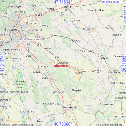
Albertirsa GPS coordinates[2]
47° 14' 35.34" North, 19° 37' 0.696" East
| Map corner | latitude | longitude |
|---|---|---|
| Upper-left | 47.71834°, | 18.91374° |
| Center: | 47.24315°, | 19.61686° |
| Lower-right: | 46.76366°, | 20.31999° |
| Map W x H: | 106.2×106.1 km | = 66×65.9mi |
| max Lat: | 48.46667° ⇑59.5% North |
| Albertirsa: | 47.24315° |
| min Lat: | ⇓40.5% South 45.79108° |
| min Long | Albertirsa | max Long |
| 16.27358° | 19.61686° | 22.68096° |
| W 52.8%⇐ | ⇒47.2% E |
Elevation
Elevation of Albertirsa is 125 m = 410 ft, and this is 4.7 m = 15 ft below average elevation for this country.
| Max E: |
444 m = 1457 ft | 40.4% |
| Avg. | 129.7 m = 426 ft | |
| Albertirsa | 125 m = 410 ft | |
Min E: |
71 m = 233 ft | 59.6% |
See also: Hungary elevation on elevation.city.
Geographical zone
Albertirsa is located in North temperate zone (between Tropic of Cancer and the Arctic Circle). Distance of this North polar circle is 2148.2 km =1334.8 mi to North.| Distance of | km | miles | from Albertirsa |
|---|---|---|---|
| North Pole | 4754.1 | 2954.1 | to North |
| Arctic Circle | 2148.2 | 1334.8 | to North |
| Tropic Cancer | 2647 | 1644.8 | to South |
| Equator | 5252.9 | 3264 | to South |


Nearby cities:
15 places around Albertirsa: (largest is in red/bold)
• Cegléd
15.9 km =9.9 mi,  119°
119°
• Ceglédbercel
4.4 km =2.7 mi, 119°
• Csemő
15 km =9.3 mi,  158°
158°
• Dánszentmiklós
6.1 km =3.8 mi,  239°
239°
• Gomba
15.6 km =9.7 mi,  335°
335°
• Hernád
16.5 km =10.3 mi, 237°
• Monor
17.6 km =10.9 mi,  313°
313°
• Nyáregyháza
9 km =5.6 mi,  283°
283°
• Pilis
7.3 km =4.5 mi, 314°
• Pánd
12.3 km =7.6 mi,  6°
6°
• Tápióbicske
14.1 km =8.8 mi,  21°
21°
• Tápiószentmárton
14.5 km =9 mi,  42°
42°
• Tápióság
17.7 km =11 mi,  3°
3°
• Örkény
18.7 km =11.6 mi,  227°
227°
• Újhartyán
17.6 km =10.9 mi,  261°
261°
Sources, notices
• [Note1] Compared only with cities in Hungary existing in our database
• [Src1] Map data: © OpenStreetMap contributors (CC-BY-SA)
• [Src2] Other city data from geonames.org with taken over terms of usage.
• [Src3] Geographical zone / Annual Mean Temperature by Robert A. Rohde @ Wikipedia
