Pázmánd geodata
Pázmánd (Fejér) is a populated place; located in Hungary in Europe/Budapest (GMT+2) time zone. With population of 1,985 people, there are 794 cities with bigger population in this country. Compared to other cities in Hungary, 57.5% of cities are located further ↑North; 74.4% of cities are located further →East and 69.8% of cities have lower elevation than Pázmánd. Note1


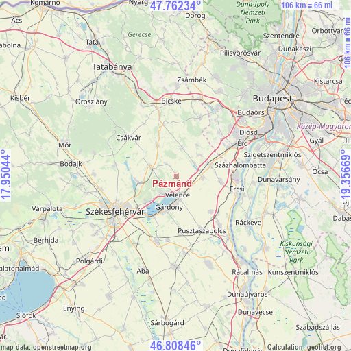
Pázmánd GPS coordinates[2]
47° 17' 15.18" North, 18° 39' 12.816" East
| Map corner | latitude | longitude |
|---|---|---|
| Upper-left | 47.76234°, | 17.95044° |
| Center: | 47.28755°, | 18.65356° |
| Lower-right: | 46.80846°, | 19.35669° |
| Map W x H: | 106.1×106.1 km | = 65.9×65.9mi |
| max Lat: | 48.46667° ⇑57.5% North |
| Pázmánd: | 47.28755° |
| min Lat: | ⇓42.5% South 45.79108° |
| min Long | Pázmánd | max Long |
| 16.27358° | 18.65356° | 22.68096° |
| W 25.6%⇐ | ⇒74.4% E |
Elevation
Elevation of Pázmánd is 137 m = 449 ft, and this is 7.3 m = 24 ft above average elevation for this country.
| Max E: |
444 m = 1457 ft | 30.2% |
| Pázmánd | 137 m 449 ft | |
| Avg. | 129.7 m = 426 ft | |
Min E: |
71 m = 233 ft | 69.8% |
See also: Hungary elevation on elevation.city.
Geographical zone
Pázmánd is located in North temperate zone (between Tropic of Cancer and the Arctic Circle). Distance of this North polar circle is 2143.3 km =1331.8 mi to North.| Distance of | km | miles | from Pázmánd |
|---|---|---|---|
| North Pole | 4749.2 | 2951 | to North |
| Arctic Circle | 2143.3 | 1331.8 | to North |
| Tropic Cancer | 2652 | 1647.9 | to South |
| Equator | 5257.9 | 3267.1 | to South |


Nearby cities:
15 places around Pázmánd: (largest is in red/bold)
• Baracska
7.9 km =4.9 mi,  94°
94°
• Csákvár
18.3 km =11.4 mi,  309°
309°
• Ercsi
18.7 km =11.6 mi,  102°
102°
• Gárdony
8.8 km =5.5 mi,  188°
188°
• Kápolnásnyék
5.5 km =3.4 mi,  162°
162°
• Lovasberény
8.1 km =5 mi,  287°
287°
• Martonvásár
10.8 km =6.7 mi,  72°
72°
• Pusztaszabolcs
18.8 km =11.7 mi,  152°
152°
• Pákozd
12.3 km =7.6 mi,  227°
227°
• Ráckeresztúr
13.7 km =8.5 mi, 96°
• Sóskút
18.4 km =11.4 mi,  43°
43°
• Tárnok
17.3 km =10.7 mi,  56°
56°
• Velence
5.4 km =3.4 mi,  178°
178°
• Vál
8.6 km =5.3 mi,  13°
13°
• Zámoly
18.8 km =11.7 mi,  279°
279°
Sources, notices
• [Note1] Compared only with cities in Hungary existing in our database
• [Src1] Map data: © OpenStreetMap contributors (CC-BY-SA)
• [Src2] Other city data from geonames.org with taken over terms of usage.
• [Src3] Geographical zone / Annual Mean Temperature by Robert A. Rohde @ Wikipedia
