Pusztaszabolcs geodata
Pusztaszabolcs (Fejér) is a populated place; located in Hungary in Europe/Budapest (GMT+2) time zone. With population of 6,355 people, there are 239 cities with bigger population in this country. Compared to other cities in Hungary, 63.9% of cities are located further ↑North; 71.6% of cities are located further →East and 58.1% of cities have higher elevation than Pusztaszabolcs. Note1


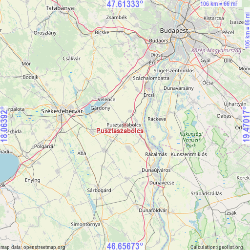
Pusztaszabolcs GPS coordinates[2]
47° 8' 13.848" North, 18° 46' 1.344" East
| Map corner | latitude | longitude |
|---|---|---|
| Upper-left | 47.61333°, | 18.06392° |
| Center: | 47.13718°, | 18.76704° |
| Lower-right: | 46.65673°, | 19.47017° |
| Map W x H: | 106.4×106.4 km | = 66.1×66.1mi |
| max Lat: | 48.46667° ⇑63.9% North |
| Pusztaszabolcs: | 47.13718° |
| min Lat: | ⇓36.1% South 45.79108° |
| min Long | Pusztaszabolcs | max Long |
| 16.27358° | 18.76704° | 22.68096° |
| W 28.4%⇐ | ⇒71.6% E |
Elevation
Elevation of Pusztaszabolcs is 111 m = 364 ft, and this is 18.7 m = 61 ft below average elevation for this country.
| Max E: |
444 m = 1457 ft | 58.1% |
| Avg. | 129.7 m = 426 ft | |
| Pusztaszabolcs | 111 m = 364 ft | |
Min E: |
71 m = 233 ft | 41.9% |
See also: Hungary elevation on elevation.city.
Geographical zone
Pusztaszabolcs is located in North temperate zone (between Tropic of Cancer and the Arctic Circle). Distance of this North polar circle is 2160 km =1342.2 mi to North.| Distance of | km | miles | from Pusztaszabolcs |
|---|---|---|---|
| North Pole | 4765.9 | 2961.4 | to North |
| Arctic Circle | 2160 | 1342.2 | to North |
| Tropic Cancer | 2635.2 | 1637.4 | to South |
| Equator | 5241.2 | 3256.7 | to South |


Nearby cities:
15 places around Pusztaszabolcs: (largest is in red/bold)
• Adony
7.7 km =4.8 mi,  104°
104°
• Baracska
16.1 km =10 mi,  357°
357°
• Ercsi
16.1 km =10 mi,  37°
37°
• Gárdony
12.7 km =7.9 mi,  309°
309°
• Iváncsa
4.6 km =2.9 mi,  61°
61°
• Kápolnásnyék
13.4 km =8.3 mi,  328°
328°
• Perkáta
10.1 km =6.3 mi,  171°
171°
• Pázmánd
18.8 km =11.7 mi, 332°
• Rácalmás
18.3 km =11.4 mi,  134°
134°
• Ráckeresztúr
16 km =9.9 mi,  18°
18°
• Ráckeve
13.7 km =8.5 mi,  78°
78°
• Seregélyes
15.6 km =9.7 mi,  259°
259°
• Szigetújfalu
16.2 km =10.1 mi,  48°
48°
• Sárosd
14.1 km =8.8 mi,  221°
221°
• Velence
14.1 km =8.8 mi,  323°
323°
Sources, notices
• [Note1] Compared only with cities in Hungary existing in our database
• [Src1] Map data: © OpenStreetMap contributors (CC-BY-SA)
• [Src2] Other city data from geonames.org with taken over terms of usage.
• [Src3] Geographical zone / Annual Mean Temperature by Robert A. Rohde @ Wikipedia
