Tóalmás geodata
Tóalmás (Pest) is a populated place; located in Hungary in Europe/Budapest (GMT+2) time zone. With population of 3,434 people, there are 426 cities with bigger population in this country. Compared to other cities in Hungary, 56.2% of cities are located further ↓South; 53.6% of cities are located further ←West and 60.4% of cities have lower elevation than Tóalmás. Note1


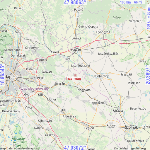
Tóalmás GPS coordinates[2]
47° 30' 28.152" North, 19° 39' 59.652" East
| Map corner | latitude | longitude |
|---|---|---|
| Upper-left | 47.98063°, | 18.96345° |
| Center: | 47.50782°, | 19.66657° |
| Lower-right: | 47.03072°, | 20.3697° |
| Map W x H: | 105.6×105.6 km | = 65.6×65.6mi |
| max Lat: | 48.46667° ⇑43.8% North |
| Tóalmás: | 47.50782° |
| min Lat: | ⇓56.2% South 45.79108° |
| min Long | Tóalmás | max Long |
| 16.27358° | 19.66657° | 22.68096° |
| W 53.6%⇐ | ⇒46.4% E |
Elevation
Elevation of Tóalmás is 126 m = 413 ft, and this is 3.7 m = 12 ft below average elevation for this country.
| Max E: |
444 m = 1457 ft | 39.6% |
| Avg. | 129.7 m = 426 ft | |
| Tóalmás | 126 m = 413 ft | |
Min E: |
71 m = 233 ft | 60.4% |
See also: Hungary elevation on elevation.city.
Geographical zone
Tóalmás is located in North temperate zone (between Tropic of Cancer and the Arctic Circle). Distance of this North polar circle is 2118.8 km =1316.6 mi to North.| Distance of | km | miles | from Tóalmás |
|---|---|---|---|
| North Pole | 4724.7 | 2935.8 | to North |
| Arctic Circle | 2118.8 | 1316.6 | to North |
| Tropic Cancer | 2676.5 | 1663.1 | to South |
| Equator | 5282.4 | 3282.3 | to South |


Nearby cities:
15 places around Tóalmás: (largest is in red/bold)
• Boldog
10.7 km =6.6 mi,  8°
8°
• Dány
9.3 km =5.8 mi,  278°
278°
• Forrópuszta
5.9 km =3.7 mi,  184°
184°
• Galgahévíz
14.2 km =8.8 mi,  328°
328°
• Kóka
7 km =4.3 mi,  249°
249°
• Nagykáta
11.8 km =7.3 mi,  150°
150°
• Szentlőrinckáta
6.6 km =4.1 mi,  78°
78°
• Szentmártonkáta
6.5 km =4 mi,  156°
156°
• Sülysáp
11.8 km =7.3 mi,  238°
238°
• Tura
12.3 km =7.6 mi,  337°
337°
• Tápiószecső
7.7 km =4.8 mi,  213°
213°
• Tápióság
12.1 km =7.5 mi,  192°
192°
• Valkó
13.1 km =8.1 mi,  298°
298°
• Vácszentlászló
12.2 km =7.6 mi,  307°
307°
• Zsámbok
5.8 km =3.6 mi, 313°
Sources, notices
• [Note1] Compared only with cities in Hungary existing in our database
• [Src1] Map data: © OpenStreetMap contributors (CC-BY-SA)
• [Src2] Other city data from geonames.org with taken over terms of usage.
• [Src3] Geographical zone / Annual Mean Temperature by Robert A. Rohde @ Wikipedia
