Szentlőrinc geodata
Szentlőrinc (Baranya) is a seat of a second-order administrative division; located in Hungary in Europe/Budapest (GMT+2) time zone. With population of 7,123 people, there are 217 cities with bigger population in this country. Compared to other cities in Hungary, 98.1% of cities are located further ↑North; 86.1% of cities are located further →East and 53.5% of cities have lower elevation than Szentlőrinc. Note1


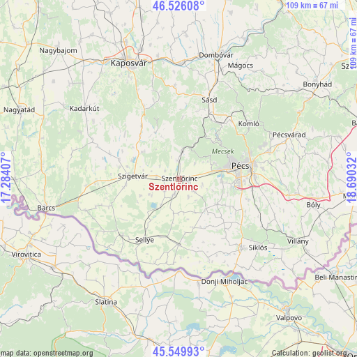
Szentlőrinc GPS coordinates[2]
46° 2' 24.576" North, 17° 59' 13.884" East
| Map corner | latitude | longitude |
|---|---|---|
| Upper-left | 46.52608°, | 17.28407° |
| Center: | 46.04016°, | 17.98719° |
| Lower-right: | 45.54993°, | 18.69032° |
| Map W x H: | 108.5×108.5 km | = 67.4×67.4mi |
| max Lat: | 48.46667° ⇑98.1% North |
| Szentlőrinc: | 46.04016° |
| min Lat: | ⇓1.9% South 45.79108° |
| min Long | Szentlőrinc | max Long |
| 16.27358° | 17.98719° | 22.68096° |
| W 13.9%⇐ | ⇒86.1% E |
Elevation
Elevation of Szentlőrinc is 119 m = 390 ft, and this is 10.7 m = 35 ft below average elevation for this country.
| Max E: |
444 m = 1457 ft | 46.5% |
| Avg. | 129.7 m = 426 ft | |
| Szentlőrinc | 119 m = 390 ft | |
Min E: |
71 m = 233 ft | 53.5% |
See also: Hungary elevation on elevation.city.
Geographical zone
Szentlőrinc is located in North temperate zone (between Tropic of Cancer and the Arctic Circle). Distance of this North polar circle is 2282 km =1418 mi to North.| Distance of | km | miles | from Szentlőrinc |
|---|---|---|---|
| North Pole | 4887.9 | 3037.2 | to North |
| Arctic Circle | 2282 | 1418 | to North |
| Tropic Cancer | 2513.3 | 1561.7 | to South |
| Equator | 5119.2 | 3180.9 | to South |


Nearby cities:
15 places around Szentlőrinc: (largest is in red/bold)
• Bükkösd
7.5 km =4.7 mi,  0°
0°
• Gödre
27.4 km =17 mi,  357°
357°
• Harkány
28.6 km =17.8 mi,  137°
137°
• Hosszúhetény
31.2 km =19.4 mi,  63°
63°
• Kadarkút
35.7 km =22.2 mi,  307°
307°
• Komló
27.3 km =17 mi,  51°
51°
• Kozármisleny
23.6 km =14.7 mi,  92°
92°
• Nagydobsza
24.8 km =15.4 mi,  268°
268°
• Pellérd
12.9 km =8 mi, 92°
• Pécs
19.6 km =12.2 mi,  75°
75°
• Sellye
21.6 km =13.4 mi,  210°
210°
• Siklós
31.6 km =19.6 mi,  130°
130°
• Szigetvár
14.1 km =8.8 mi, 273°
• Sásd
25.7 km =16 mi,  21°
21°
• Vajszló
20.1 km =12.5 mi,  180°
180°
Sources, notices
• [Note1] Compared only with cities in Hungary existing in our database
• [Src1] Map data: © OpenStreetMap contributors (CC-BY-SA)
• [Src2] Other city data from geonames.org with taken over terms of usage.
• [Src3] Geographical zone / Annual Mean Temperature by Robert A. Rohde @ Wikipedia
