Fülöpszállás geodata
Fülöpszállás (Bács-Kiskun) is a populated place; located in Hungary in Europe/Budapest (GMT+2) time zone. With population of 2,503 people, there are 618 cities with bigger population in this country. Compared to other cities in Hungary, 75.7% of cities are located further ↑North; 55.9% of cities are located further →East and 78.9% of cities have higher elevation than Fülöpszállás. Note1


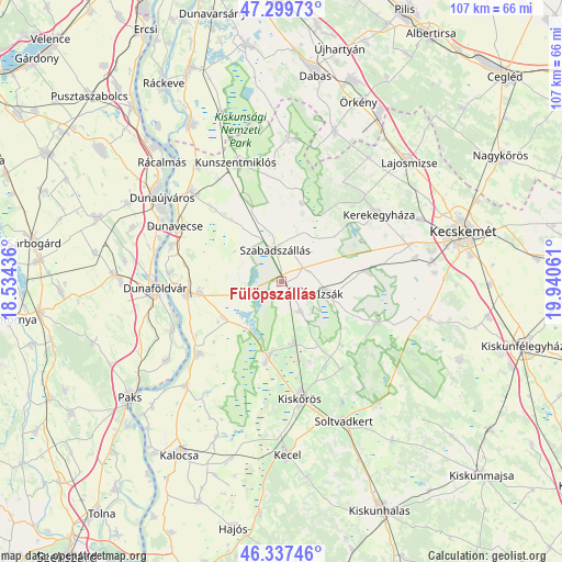
Fülöpszállás GPS coordinates[2]
46° 49' 14.7" North, 19° 14' 14.928" East
| Map corner | latitude | longitude |
|---|---|---|
| Upper-left | 47.29973°, | 18.53436° |
| Center: | 46.82075°, | 19.23748° |
| Lower-right: | 46.33746°, | 19.94061° |
| Map W x H: | 107×107 km | = 66.5×66.5mi |
| max Lat: | 48.46667° ⇑75.7% North |
| Fülöpszállás: | 46.82075° |
| min Lat: | ⇓24.3% South 45.79108° |
| min Long | Fülöpszállá | max Long |
| 16.27358° | 19.23748° | 22.68096° |
| W 44.1%⇐ | ⇒55.9% E |
Elevation
Elevation of Fülöpszállás is 96 m = 315 ft, and this is 33.7 m = 111 ft below average elevation for this country.
| Max E: |
444 m = 1457 ft | 78.9% |
| Avg. | 129.7 m = 426 ft | |
| Fülöpszállás | 96 m = 315 ft | |
Min E: |
71 m = 233 ft | 21.1% |
See also: Hungary elevation on elevation.city.
Geographical zone
Fülöpszállás is located in North temperate zone (between Tropic of Cancer and the Arctic Circle). Distance of this North polar circle is 2195.2 km =1364 mi to North.| Distance of | km | miles | from Fülöpszállás |
|---|---|---|---|
| North Pole | 4801.1 | 2983.3 | to North |
| Arctic Circle | 2195.2 | 1364 | to North |
| Tropic Cancer | 2600.1 | 1615.6 | to South |
| Equator | 5206 | 3234.9 | to South |


Nearby cities:
15 places around Fülöpszállás: (largest is in red/bold)
• Akasztó
14.6 km =9.1 mi,  190°
190°
• Apostag
22 km =13.7 mi,  288°
288°
• Bölcske
22.4 km =13.9 mi,  246°
246°
• Csengőd
11.9 km =7.4 mi,  168°
168°
• Dunaföldvár
23.6 km =14.7 mi,  266°
266°
• Dunavecse
22.8 km =14.2 mi,  297°
297°
• Harta
20.8 km =12.9 mi,  228°
228°
• Izsák
8.9 km =5.5 mi,  101°
101°
• Kerekegyháza
22.4 km =13.9 mi,  54°
54°
• Kiskőrös
22.5 km =14 mi, 170°
• Orgovány
19.5 km =12.1 mi,  113°
113°
• Solt
18.1 km =11.2 mi,  263°
263°
• Szabadszállás
6.2 km =3.9 mi,  349°
349°
• Szalkszentmárton
24.3 km =15.1 mi,  315°
315°
• Ágasegyháza
16.5 km =10.3 mi,  82°
82°
Sources, notices
• [Note1] Compared only with cities in Hungary existing in our database
• [Src1] Map data: © OpenStreetMap contributors (CC-BY-SA)
• [Src2] Other city data from geonames.org with taken over terms of usage.
• [Src3] Geographical zone / Annual Mean Temperature by Robert A. Rohde @ Wikipedia
