Dunavecse geodata
Dunavecse (Bács-Kiskun) is a populated place; located in Hungary in Europe/Budapest (GMT+2) time zone. With population of 4,201 people, there are 357 cities with bigger population in this country. Compared to other cities in Hungary, 72% of cities are located further ↑North; 65.1% of cities are located further →East and 53.5% of cities have lower elevation than Dunavecse. Note1


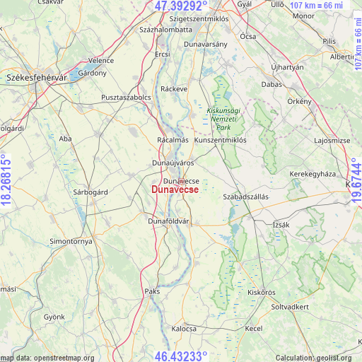
Dunavecse GPS coordinates[2]
46° 54' 53.208" North, 18° 58' 16.572" East
| Map corner | latitude | longitude |
|---|---|---|
| Upper-left | 47.39292°, | 18.26815° |
| Center: | 46.91478°, | 18.97127° |
| Lower-right: | 46.43233°, | 19.6744° |
| Map W x H: | 106.8×106.8 km | = 66.4×66.4mi |
| max Lat: | 48.46667° ⇑72% North |
| Dunavecse: | 46.91478° |
| min Lat: | ⇓28% South 45.79108° |
| min Long | Dunavecse | max Long |
| 16.27358° | 18.97127° | 22.68096° |
| W 34.9%⇐ | ⇒65.1% E |
Elevation
Elevation of Dunavecse is 119 m = 390 ft, and this is 10.7 m = 35 ft below average elevation for this country.
| Max E: |
444 m = 1457 ft | 46.5% |
| Avg. | 129.7 m = 426 ft | |
| Dunavecse | 119 m = 390 ft | |
Min E: |
71 m = 233 ft | 53.5% |
See also: Hungary elevation on elevation.city.
Geographical zone
Dunavecse is located in North temperate zone (between Tropic of Cancer and the Arctic Circle). Distance of this North polar circle is 2184.7 km =1357.5 mi to North.| Distance of | km | miles | from Dunavecse |
|---|---|---|---|
| North Pole | 4790.6 | 2976.7 | to North |
| Arctic Circle | 2184.7 | 1357.5 | to North |
| Tropic Cancer | 2610.5 | 1622.1 | to South |
| Equator | 5216.4 | 3241.3 | to South |


Nearby cities:
15 places around Dunavecse: (largest is in red/bold)
• Apostag
3.7 km =2.3 mi,  190°
190°
• Baracs
6.1 km =3.8 mi,  233°
233°
• Bölcske
19.3 km =12 mi,  180°
180°
• Dunaföldvár
12.4 km =7.7 mi,  195°
195°
• Dunaújváros
6.1 km =3.8 mi,  336°
336°
• Dömsöd
19.7 km =12.2 mi,  8°
8°
• Előszállás
13.9 km =8.6 mi, 228°
• Kunszentmiklós
17.1 km =10.6 mi,  43°
43°
• Mezőfalva
15.3 km =9.5 mi,  277°
277°
• Rácalmás
12.2 km =7.6 mi,  349°
349°
• Solt
12.9 km =8 mi,  169°
169°
• Szabadszállás
19.6 km =12.2 mi,  102°
102°
• Szalkszentmárton
7.4 km =4.6 mi,  24°
24°
• Tass
12.6 km =7.8 mi, 20°
• dunaújváros
6.5 km =4 mi,  333°
333°
Sources, notices
• [Note1] Compared only with cities in Hungary existing in our database
• [Src1] Map data: © OpenStreetMap contributors (CC-BY-SA)
• [Src2] Other city data from geonames.org with taken over terms of usage.
• [Src3] Geographical zone / Annual Mean Temperature by Robert A. Rohde @ Wikipedia
