Érd geodata
Érd (Pest) is a seat of a second-order administrative division; located in Hungary in Europe/Budapest (GMT+2) time zone. With population of 62,408 people, there are 30 cities with bigger population in this country. Compared to other cities in Hungary, 51% of cities are located further ↑North; 68% of cities are located further →East and 76.6% of cities have lower elevation than Érd. Note1


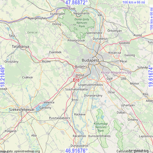
Érd GPS coordinates[2]
47° 23' 41.604" North, 18° 54' 48.996" East
| Map corner | latitude | longitude |
|---|---|---|
| Upper-left | 47.86872°, | 18.21049° |
| Center: | 47.39489°, | 18.91361° |
| Lower-right: | 46.91676°, | 19.61674° |
| Map W x H: | 105.8×105.8 km | = 65.7×65.7mi |
| max Lat: | 48.46667° ⇑51% North |
| Érd: | 47.39489° |
| min Lat: | ⇓49% South 45.79108° |
| min Long | Érd | max Long |
| 16.27358° | 18.91361° | 22.68096° |
| W 32%⇐ | ⇒68% E |
Elevation
Elevation of Érd is 150 m = 492 ft, and this is 20.3 m = 67 ft above average elevation for this country.
| Max E: |
444 m = 1457 ft | 23.4% |
| Érd | 150 m 492 ft | |
| Avg. | 129.7 m = 426 ft | |
Min E: |
71 m = 233 ft | 76.6% |
See also: Érd elevation on elevation.city.
Geographical zone
Érd is located in North temperate zone (between Tropic of Cancer and the Arctic Circle). Distance of this North polar circle is 2131.4 km =1324.4 mi to North.| Distance of | km | miles | from Érd |
|---|---|---|---|
| North Pole | 4737.2 | 2943.6 | to North |
| Arctic Circle | 2131.4 | 1324.4 | to North |
| Tropic Cancer | 2663.9 | 1655.3 | to South |
| Equator | 5269.8 | 3274.5 | to South |


Nearby cities:
15 places around Érd: (largest is in red/bold)
• Biatorbágy
11 km =6.8 mi,  319°
319°
• Budakeszi
12.9 km =8 mi,  4°
4°
• Budapest XXI. kerület
12.5 km =7.8 mi,  71°
71°
• Budapest XXII. kerület
10.2 km =6.3 mi, 69°
• Budaörs
8.2 km =5.1 mi,  24°
24°
• Diósd
3.1 km =1.9 mi,  58°
58°
• Halásztelek
6.3 km =3.9 mi,  125°
125°
• Martonvásár
12.8 km =8 mi,  226°
226°
• Szigethalom
10.5 km =6.5 mi,  140°
140°
• Szigetszentmiklós
11.3 km =7 mi,  120°
120°
• Százhalombatta
7.5 km =4.7 mi,  165°
165°
• Sóskút
7 km =4.3 mi,  280°
280°
• Tárnok
5.6 km =3.5 mi,  244°
244°
• Tököl
8.9 km =5.5 mi,  155°
155°
• Törökbálint
3.8 km =2.4 mi,  359°
359°
Sources, notices
• [Note1] Compared only with cities in Hungary existing in our database
• [Src1] Map data: © OpenStreetMap contributors (CC-BY-SA)
• [Src2] Other city data from geonames.org with taken over terms of usage.
• [Src3] Geographical zone / Annual Mean Temperature by Robert A. Rohde @ Wikipedia
