Biatorbágy geodata
Biatorbágy (Pest) is a populated place; located in Hungary in Europe/Budapest (GMT+2) time zone. With population of 8,632 people, there are 188 cities with bigger population in this country. Compared to other cities in Hungary, 53.8% of cities are located further ↓South; 70.6% of cities are located further →East and 82.9% of cities have lower elevation than Biatorbágy. Note1


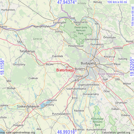
Biatorbágy GPS coordinates[2]
47° 28' 14.16" North, 18° 49' 8.112" East
| Map corner | latitude | longitude |
|---|---|---|
| Upper-left | 47.94374°, | 18.1158° |
| Center: | 47.4706°, | 18.81892° |
| Lower-right: | 46.99316°, | 19.52205° |
| Map W x H: | 105.7×105.7 km | = 65.7×65.7mi |
| max Lat: | 48.46667° ⇑46.2% North |
| Biatorbágy: | 47.4706° |
| min Lat: | ⇓53.8% South 45.79108° |
| min Long | Biatorbágy | max Long |
| 16.27358° | 18.81892° | 22.68096° |
| W 29.4%⇐ | ⇒70.6% E |
Elevation
Elevation of Biatorbágy is 167 m = 548 ft, and this is 37.3 m = 122 ft above average elevation for this country.
| Max E: |
444 m = 1457 ft | 17.1% |
| Biatorbágy | 167 m 548 ft | |
| Avg. | 129.7 m = 426 ft | |
Min E: |
71 m = 233 ft | 82.9% |
See also: Hungary elevation on elevation.city.
Geographical zone
Biatorbágy is located in North temperate zone (between Tropic of Cancer and the Arctic Circle). Distance of this North polar circle is 2122.9 km =1319.1 mi to North.| Distance of | km | miles | from Biatorbágy |
|---|---|---|---|
| North Pole | 4728.8 | 2938.3 | to North |
| Arctic Circle | 2122.9 | 1319.1 | to North |
| Tropic Cancer | 2672.3 | 1660.5 | to South |
| Equator | 5278.2 | 3279.7 | to South |


Nearby cities:
15 places around Biatorbágy: (largest is in red/bold)
• Bicske
13.2 km =8.2 mi,  276°
276°
• Budakeszi
9.3 km =5.8 mi,  61°
61°
• Budaörs
10.5 km =6.5 mi,  95°
95°
• Diósd
11.9 km =7.4 mi,  124°
124°
• Etyek
5.5 km =3.4 mi,  242°
242°
• Mány
14.1 km =8.8 mi,  299°
299°
• Perbál
13.9 km =8.6 mi,  341°
341°
• Páty
5.2 km =3.2 mi,  7°
7°
• Remeteszőlős
12.5 km =7.8 mi,  37°
37°
• Sóskút
7.1 km =4.4 mi,  177°
177°
• Telki
8.6 km =5.3 mi,  4°
4°
• Tárnok
11 km =6.8 mi,  169°
169°
• Törökbálint
8.5 km =5.3 mi, 122°
• Zsámbék
11.4 km =7.1 mi,  319°
319°
• Érd
11 km =6.8 mi,  139°
139°
Sources, notices
• [Note1] Compared only with cities in Hungary existing in our database
• [Src1] Map data: © OpenStreetMap contributors (CC-BY-SA)
• [Src2] Other city data from geonames.org with taken over terms of usage.
• [Src3] Geographical zone / Annual Mean Temperature by Robert A. Rohde @ Wikipedia
