Halásztelek geodata
Halásztelek (Pest) is a populated place; located in Hungary in Europe/Budapest (GMT+2) time zone. With population of 7,245 people, there are 211 cities with bigger population in this country. Compared to other cities in Hungary, 53.4% of cities are located further ↑North; 64.9% of cities are located further →East and 74.5% of cities have higher elevation than Halásztelek. Note1


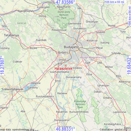
Halásztelek GPS coordinates[2]
47° 21' 42.228" North, 18° 58' 52.284" East
| Map corner | latitude | longitude |
|---|---|---|
| Upper-left | 47.83586°, | 18.27807° |
| Center: | 47.36173°, | 18.98119° |
| Lower-right: | 46.88331°, | 19.68432° |
| Map W x H: | 105.9×105.9 km | = 65.8×65.8mi |
| max Lat: | 48.46667° ⇑53.4% North |
| Halásztelek: | 47.36173° |
| min Lat: | ⇓46.6% South 45.79108° |
| min Long | Halásztelek | max Long |
| 16.27358° | 18.98119° | 22.68096° |
| W 35.1%⇐ | ⇒64.9% E |
Elevation
Elevation of Halásztelek is 99 m = 325 ft, and this is 30.7 m = 101 ft below average elevation for this country.
| Max E: |
444 m = 1457 ft | 74.5% |
| Avg. | 129.7 m = 426 ft | |
| Halásztelek | 99 m = 325 ft | |
Min E: |
71 m = 233 ft | 25.5% |
See also: Hungary elevation on elevation.city.
Geographical zone
Halásztelek is located in North temperate zone (between Tropic of Cancer and the Arctic Circle). Distance of this North polar circle is 2135 km =1326.6 mi to North.| Distance of | km | miles | from Halásztelek |
|---|---|---|---|
| North Pole | 4740.9 | 2945.9 | to North |
| Arctic Circle | 2135 | 1326.6 | to North |
| Tropic Cancer | 2660.2 | 1653 | to South |
| Equator | 5266.1 | 3272.2 | to South |


Nearby cities:
15 places around Halásztelek: (largest is in red/bold)
• Budapest XXI. kerület
10.2 km =6.3 mi,  41°
41°
• Budapest XXII. kerület
8.5 km =5.3 mi,  31°
31°
• Budapest XXIII. kerület
10.8 km =6.7 mi,  68°
68°
• Diósd
5.8 km =3.6 mi,  335°
335°
• Dunaharaszti
8.9 km =5.5 mi,  95°
95°
• Dunavarsány
11.2 km =7 mi,  145°
145°
• Szigetcsép
10.8 km =6.7 mi,  184°
184°
• Szigethalom
4.7 km =2.9 mi,  159°
159°
• Szigetszentmiklós
5.1 km =3.2 mi,  113°
113°
• Százhalombatta
4.8 km =3 mi,  221°
221°
• Taksony
7.4 km =4.6 mi,  118°
118°
• Tárnok
10.3 km =6.4 mi,  277°
277°
• Tököl
4.7 km =2.9 mi,  197°
197°
• Törökbálint
9.1 km =5.7 mi,  325°
325°
• Érd
6.3 km =3.9 mi,  305°
305°
Sources, notices
• [Note1] Compared only with cities in Hungary existing in our database
• [Src1] Map data: © OpenStreetMap contributors (CC-BY-SA)
• [Src2] Other city data from geonames.org with taken over terms of usage.
• [Src3] Geographical zone / Annual Mean Temperature by Robert A. Rohde @ Wikipedia
