Tököl geodata
Tököl (Pest) is a populated place; located in Hungary in Europe/Budapest (GMT+2) time zone. With population of 10,164 people, there are 163 cities with bigger population in this country. Compared to other cities in Hungary, 55.5% of cities are located further ↑North; 65.7% of cities are located further →East and 72.5% of cities have higher elevation than Tököl. Note1


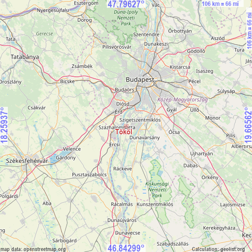
Tököl GPS coordinates[2]
47° 19' 18.408" North, 18° 57' 44.964" East
| Map corner | latitude | longitude |
|---|---|---|
| Upper-left | 47.79627°, | 18.25937° |
| Center: | 47.32178°, | 18.96249° |
| Lower-right: | 46.84299°, | 19.66562° |
| Map W x H: | 106×106 km | = 65.9×65.9mi |
| max Lat: | 48.46667° ⇑55.5% North |
| Tököl: | 47.32178° |
| min Lat: | ⇓44.5% South 45.79108° |
| min Long | Tököl | max Long |
| 16.27358° | 18.96249° | 22.68096° |
| W 34.3%⇐ | ⇒65.7% E |
Elevation
Elevation of Tököl is 100 m = 328 ft, and this is 29.7 m = 97 ft below average elevation for this country.
| Max E: |
444 m = 1457 ft | 72.5% |
| Avg. | 129.7 m = 426 ft | |
| Tököl | 100 m = 328 ft | |
Min E: |
71 m = 233 ft | 27.5% |
See also: Hungary elevation on elevation.city.
Geographical zone
Tököl is located in North temperate zone (between Tropic of Cancer and the Arctic Circle). Distance of this North polar circle is 2139.5 km =1329.4 mi to North.| Distance of | km | miles | from Tököl |
|---|---|---|---|
| North Pole | 4745.4 | 2948.7 | to North |
| Arctic Circle | 2139.5 | 1329.4 | to North |
| Tropic Cancer | 2655.8 | 1650.2 | to South |
| Equator | 5261.7 | 3269.5 | to South |


Nearby cities:
15 places around Tököl: (largest is in red/bold)
• Diósd
9.8 km =6.1 mi,  354°
354°
• Dunaharaszti
10.9 km =6.8 mi,  70°
70°
• Dunavarsány
9.2 km =5.7 mi,  121°
121°
• Ercsi
9.2 km =5.7 mi,  212°
212°
• Halásztelek
4.7 km =2.9 mi,  17°
17°
• Ráckeresztúr
11.1 km =6.9 mi,  241°
241°
• Szigetcsép
6.4 km =4 mi,  174°
174°
• Szigethalom
3 km =1.9 mi,  88°
88°
• Szigetszentmiklós
6.6 km =4.1 mi, 68°
• Szigetújfalu
10.1 km =6.3 mi,  195°
195°
• Százhalombatta
2 km =1.2 mi,  295°
295°
• Taksony
7.9 km =4.9 mi,  83°
83°
• Tárnok
10.5 km =6.5 mi, 303°
• Törökbálint
12.5 km =7.8 mi,  342°
342°
• Érd
8.9 km =5.5 mi, 335°
Sources, notices
• [Note1] Compared only with cities in Hungary existing in our database
• [Src1] Map data: © OpenStreetMap contributors (CC-BY-SA)
• [Src2] Other city data from geonames.org with taken over terms of usage.
• [Src3] Geographical zone / Annual Mean Temperature by Robert A. Rohde @ Wikipedia
