Dömsöd geodata
Dömsöd (Pest) is a populated place; located in Hungary in Europe/Budapest (GMT+2) time zone. With population of 5,942 people, there are 259 cities with bigger population in this country. Compared to other cities in Hungary, 66.1% of cities are located further ↑North; 63.8% of cities are located further →East and 77% of cities have higher elevation than Dömsöd. Note1


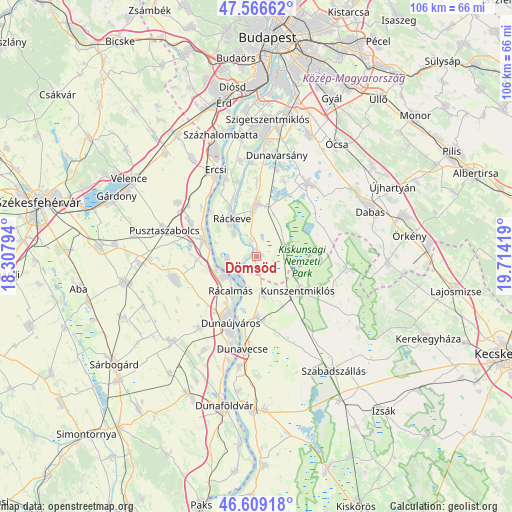
Dömsöd GPS coordinates[2]
47° 5' 24.18" North, 19° 0' 39.816" East
| Map corner | latitude | longitude |
|---|---|---|
| Upper-left | 47.56662°, | 18.30794° |
| Center: | 47.09005°, | 19.01106° |
| Lower-right: | 46.60918°, | 19.71419° |
| Map W x H: | 106.5×106.5 km | = 66.2×66.2mi |
| max Lat: | 48.46667° ⇑66.1% North |
| Dömsöd: | 47.09005° |
| min Lat: | ⇓33.9% South 45.79108° |
| min Long | Dömsöd | max Long |
| 16.27358° | 19.01106° | 22.68096° |
| W 36.2%⇐ | ⇒63.8% E |
Elevation
Elevation of Dömsöd is 97 m = 318 ft, and this is 32.7 m = 107 ft below average elevation for this country.
| Max E: |
444 m = 1457 ft | 77% |
| Avg. | 129.7 m = 426 ft | |
| Dömsöd | 97 m = 318 ft | |
Min E: |
71 m = 233 ft | 23% |
See also: Hungary elevation on elevation.city.
Geographical zone
Dömsöd is located in North temperate zone (between Tropic of Cancer and the Arctic Circle). Distance of this North polar circle is 2165.3 km =1345.5 mi to North.| Distance of | km | miles | from Dömsöd |
|---|---|---|---|
| North Pole | 4771.1 | 2964.6 | to North |
| Arctic Circle | 2165.3 | 1345.5 | to North |
| Tropic Cancer | 2630 | 1634.2 | to South |
| Equator | 5235.9 | 3253.4 | to South |


Nearby cities:
15 places around Dömsöd: (largest is in red/bold)
• Adony
11.5 km =7.1 mi,  286°
286°
• Bugyi
18.4 km =11.4 mi,  33°
33°
• Dunaújváros
14.9 km =9.3 mi,  201°
201°
• Délegyháza
17.9 km =11.1 mi,  19°
19°
• Iváncsa
16.2 km =10.1 mi,  297°
297°
• Kiskunlacháza
10.9 km =6.8 mi,  359°
359°
• Kunszentmiklós
11.2 km =7 mi,  128°
128°
• Perkáta
17.6 km =10.9 mi,  254°
254°
• Pusztaszabolcs
19.2 km =11.9 mi, 285°
• Rácalmás
9.2 km =5.7 mi,  215°
215°
• Ráckeve
9.3 km =5.8 mi,  327°
327°
• Szalkszentmárton
12.7 km =7.9 mi,  179°
179°
• Szigetújfalu
17.2 km =10.7 mi,  338°
338°
• Tass
7.8 km =4.8 mi,  169°
169°
• dunaújváros
14.9 km =9.3 mi, 203°
Sources, notices
• [Note1] Compared only with cities in Hungary existing in our database
• [Src1] Map data: © OpenStreetMap contributors (CC-BY-SA)
• [Src2] Other city data from geonames.org with taken over terms of usage.
• [Src3] Geographical zone / Annual Mean Temperature by Robert A. Rohde @ Wikipedia
