Dunaújváros geodata
Dunaújváros (Fejér) is a populated place; located in Hungary in Europe/Budapest (GMT+2) time zone. With population of 50,084 people, there are 41 cities with bigger population in this country. Compared to other cities in Hungary, 70.5% of cities are located further ↑North; 66.9% of cities are located further →East and 74.4% of cities have lower elevation than Dunaújváros. Note1


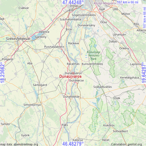
Dunaújváros GPS coordinates[2]
46° 57' 53.244" North, 18° 56' 23.064" East
| Map corner | latitude | longitude |
|---|---|---|
| Upper-left | 47.44248°, | 18.23662° |
| Center: | 46.96479°, | 18.93974° |
| Lower-right: | 46.48279°, | 19.64287° |
| Map W x H: | 106.7×106.7 km | = 66.3×66.3mi |
| max Lat: | 48.46667° ⇑70.5% North |
| Dunaújváros: | 46.96479° |
| min Lat: | ⇓29.5% South 45.79108° |
| min Long | Dunaújváros | max Long |
| 16.27358° | 18.93974° | 22.68096° |
| W 33.1%⇐ | ⇒66.9% E |
Elevation
Elevation of Dunaújváros is 146 m = 479 ft, and this is 16.3 m = 53 ft above average elevation for this country.
| Max E: |
444 m = 1457 ft | 25.6% |
| Dunaújváros | 146 m 479 ft | |
| Avg. | 129.7 m = 426 ft | |
Min E: |
71 m = 233 ft | 74.4% |
See also: Dunaújváros elevation on elevation.city.
Geographical zone
Dunaújváros is located in North temperate zone (between Tropic of Cancer and the Arctic Circle). Distance of this North polar circle is 2179.2 km =1354.1 mi to North.| Distance of | km | miles | from Dunaújváros |
|---|---|---|---|
| North Pole | 4785.1 | 2973.3 | to North |
| Arctic Circle | 2179.2 | 1354.1 | to North |
| Tropic Cancer | 2616.1 | 1625.6 | to South |
| Equator | 5222 | 3244.8 | to South |


Nearby cities:
15 places around Dunaújváros: (largest is in red/bold)
• Adony
18.1 km =11.2 mi,  341°
341°
• Apostag
9.4 km =5.8 mi,  169°
169°
• Baracs
9.5 km =5.9 mi,  195°
195°
• Dunaföldvár
17.6 km =10.9 mi,  183°
183°
• Dunavecse
6.1 km =3.8 mi,  156°
156°
• Dömsöd
14.9 km =9.3 mi,  21°
21°
• Előszállás
16.9 km =10.5 mi,  208°
208°
• Kunszentmiklós
15.7 km =9.8 mi,  63°
63°
• Mezőfalva
13.3 km =8.3 mi,  253°
253°
• Perkáta
14.7 km =9.1 mi,  308°
308°
• Rácalmás
6.4 km =4 mi,  0°
0°
• Solt
18.8 km =11.7 mi, 165°
• Szalkszentmárton
5.6 km =3.5 mi,  77°
77°
• Tass
9.3 km =5.8 mi,  47°
47°
• dunaújváros
0.6 km =0.4 mi,  298°
298°
Sources, notices
• [Note1] Compared only with cities in Hungary existing in our database
• [Src1] Map data: © OpenStreetMap contributors (CC-BY-SA)
• [Src2] Other city data from geonames.org with taken over terms of usage.
• [Src3] Geographical zone / Annual Mean Temperature by Robert A. Rohde @ Wikipedia
