Rácalmás geodata
Rácalmás (Fejér) is a populated place; located in Hungary in Europe/Budapest (GMT+2) time zone. With population of 4,148 people, there are 360 cities with bigger population in this country. Compared to other cities in Hungary, 68.5% of cities are located further ↑North; 66.8% of cities are located further →East and 71.9% of cities have lower elevation than Rácalmás. Note1


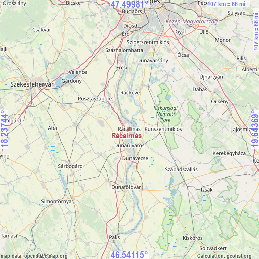
Rácalmás GPS coordinates[2]
47° 1' 21.468" North, 18° 56' 26.016" East
| Map corner | latitude | longitude |
|---|---|---|
| Upper-left | 47.49981°, | 18.23744° |
| Center: | 47.02263°, | 18.94056° |
| Lower-right: | 46.54115°, | 19.64369° |
| Map W x H: | 106.6×106.6 km | = 66.2×66.2mi |
| max Lat: | 48.46667° ⇑68.5% North |
| Rácalmás: | 47.02263° |
| min Lat: | ⇓31.5% South 45.79108° |
| min Long | Rácalmás | max Long |
| 16.27358° | 18.94056° | 22.68096° |
| W 33.2%⇐ | ⇒66.8% E |
Elevation
Elevation of Rácalmás is 140 m = 459 ft, and this is 10.3 m = 34 ft above average elevation for this country.
| Max E: |
444 m = 1457 ft | 28.1% |
| Rácalmás | 140 m 459 ft | |
| Avg. | 129.7 m = 426 ft | |
Min E: |
71 m = 233 ft | 71.9% |
See also: Hungary elevation on elevation.city.
Geographical zone
Rácalmás is located in North temperate zone (between Tropic of Cancer and the Arctic Circle). Distance of this North polar circle is 2172.7 km =1350.1 mi to North.| Distance of | km | miles | from Rácalmás |
|---|---|---|---|
| North Pole | 4778.6 | 2969.3 | to North |
| Arctic Circle | 2172.7 | 1350.1 | to North |
| Tropic Cancer | 2622.5 | 1629.5 | to South |
| Equator | 5228.4 | 3248.8 | to South |


Nearby cities:
15 places around Rácalmás: (largest is in red/bold)
• Adony
12.2 km =7.6 mi,  331°
331°
• Apostag
15.7 km =9.8 mi,  174°
174°
• Baracs
15.8 km =9.8 mi,  189°
189°
• Dunavecse
12.2 km =7.6 mi, 169°
• Dunaújváros
6.4 km =4 mi,  180°
180°
• Dömsöd
9.2 km =5.7 mi,  35°
35°
• Iváncsa
17.5 km =10.9 mi, 328°
• Kunszentmiklós
14 km =8.7 mi,  88°
88°
• Mezőfalva
16.3 km =10.1 mi,  231°
231°
• Perkáta
11.9 km =7.4 mi,  283°
283°
• Pusztaszabolcs
18.3 km =11.4 mi,  314°
314°
• Ráckeve
15.4 km =9.6 mi,  1°
1°
• Szalkszentmárton
7.5 km =4.7 mi,  134°
134°
• Tass
6.8 km =4.2 mi, 91°
• dunaújváros
6.2 km =3.9 mi, 185°
Sources, notices
• [Note1] Compared only with cities in Hungary existing in our database
• [Src1] Map data: © OpenStreetMap contributors (CC-BY-SA)
• [Src2] Other city data from geonames.org with taken over terms of usage.
• [Src3] Geographical zone / Annual Mean Temperature by Robert A. Rohde @ Wikipedia
