Perbál geodata
Perbál (Pest) is a populated place; located in Hungary in Europe/Budapest (GMT+2) time zone. With population of 2,167 people, there are 723 cities with bigger population in this country. Compared to other cities in Hungary, 61.4% of cities are located further ↓South; 71.8% of cities are located further →East and 91.7% of cities have lower elevation than Perbál. Note1


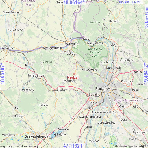
Perbál GPS coordinates[2]
47° 35' 22.452" North, 18° 45' 39.564" East
| Map corner | latitude | longitude |
|---|---|---|
| Upper-left | 48.06164°, | 18.05787° |
| Center: | 47.58957°, | 18.76099° |
| Lower-right: | 47.11321°, | 19.46412° |
| Map W x H: | 105.5×105.5 km | = 65.6×65.6mi |
| max Lat: | 48.46667° ⇑38.6% North |
| Perbál: | 47.58957° |
| min Lat: | ⇓61.4% South 45.79108° |
| min Long | Perbál | max Long |
| 16.27358° | 18.76099° | 22.68096° |
| W 28.2%⇐ | ⇒71.8% E |
Elevation
Elevation of Perbál is 197 m = 646 ft, and this is 67.3 m = 221 ft above average elevation for this country.
| Max E: |
444 m = 1457 ft | 8.3% |
| Perbál | 197 m 646 ft | |
| Avg. | 129.7 m = 426 ft | |
Min E: |
71 m = 233 ft | 91.7% |
See also: Hungary elevation on elevation.city.
Geographical zone
Perbál is located in North temperate zone (between Tropic of Cancer and the Arctic Circle). Distance of this North polar circle is 2109.7 km =1310.9 mi to North.| Distance of | km | miles | from Perbál |
|---|---|---|---|
| North Pole | 4715.6 | 2930.1 | to North |
| Arctic Circle | 2109.7 | 1310.9 | to North |
| Tropic Cancer | 2685.5 | 1668.7 | to South |
| Equator | 5291.5 | 3288 | to South |


Nearby cities:
15 places around Perbál: (largest is in red/bold)
• Biatorbágy
13.9 km =8.6 mi,  161°
161°
• Csolnok
11.8 km =7.3 mi,  343°
343°
• Kesztölc
14 km =8.7 mi,  12°
12°
• Mány
10 km =6.2 mi,  231°
231°
• Piliscsaba
7.1 km =4.4 mi,  45°
45°
• Piliscsév
10.9 km =6.8 mi,  23°
23°
• Pilisszentiván
10.6 km =6.6 mi,  77°
77°
• Pilisszántó
13 km =8.1 mi, 47°
• Pilisvörösvár
11.4 km =7.1 mi, 76°
• Páty
9.5 km =5.9 mi,  147°
147°
• Remeteszőlős
12.4 km =7.7 mi,  105°
105°
• Solymár
12.8 km =8 mi,  88°
88°
• Sárisáp
11.5 km =7.1 mi,  327°
327°
• Telki
6.8 km =4.2 mi,  132°
132°
• Zsámbék
5.5 km =3.4 mi,  213°
213°
Sources, notices
• [Note1] Compared only with cities in Hungary existing in our database
• [Src1] Map data: © OpenStreetMap contributors (CC-BY-SA)
• [Src2] Other city data from geonames.org with taken over terms of usage.
• [Src3] Geographical zone / Annual Mean Temperature by Robert A. Rohde @ Wikipedia
