Balassagyarmat geodata
Balassagyarmat (Nógrád) is a seat of a second-order administrative division; located in Hungary in Europe/Budapest (GMT+2) time zone. With population of 17,541 people, there are 101 cities with bigger population in this country. Compared to other cities in Hungary, 90.5% of cities are located further ↓South; 54.4% of cities are located further →East and 76.6% of cities have lower elevation than Balassagyarmat. Note1


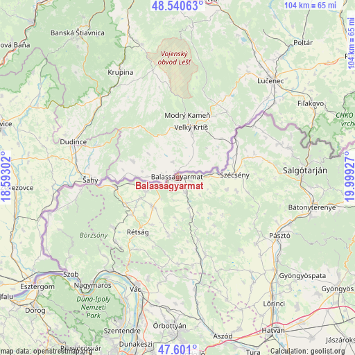
Balassagyarmat GPS coordinates[2]
48° 4' 22.656" North, 19° 17' 46.104" East
| Map corner | latitude | longitude |
|---|---|---|
| Upper-left | 48.54063°, | 18.59302° |
| Center: | 48.07296°, | 19.29614° |
| Lower-right: | 47.601°, | 19.99927° |
| Map W x H: | 104.5×104.5 km | = 64.9×64.9mi |
| max Lat: | 48.46667° ⇑9.5% North |
| Balassagyarmat: | 48.07296° |
| min Lat: | ⇓90.5% South 45.79108° |
| min Long | Balassagyarmat | max Long |
| 16.27358° | 19.29614° | 22.68096° |
| W 45.6%⇐ | ⇒54.4% E |
Elevation
Elevation of Balassagyarmat is 150 m = 492 ft, and this is 20.3 m = 67 ft above average elevation for this country.
| Max E: |
444 m = 1457 ft | 23.4% |
| Balassagyarmat | 150 m 492 ft | |
| Avg. | 129.7 m = 426 ft | |
Min E: |
71 m = 233 ft | 76.6% |
See also: Hungary elevation on elevation.city.
Geographical zone
Balassagyarmat is located in North temperate zone (between Tropic of Cancer and the Arctic Circle). Distance of this North polar circle is 2056 km =1277.5 mi to North.| Distance of | km | miles | from Balassagyarmat |
|---|---|---|---|
| North Pole | 4661.8 | 2896.7 | to North |
| Arctic Circle | 2056 | 1277.5 | to North |
| Tropic Cancer | 2739.3 | 1702.1 | to South |
| Equator | 5345.2 | 3321.4 | to South |


Nearby cities:
15 places around Balassagyarmat: (largest is in red/bold)
• Acsa
31.7 km =19.7 mi,  167°
167°
• Bercel
24 km =14.9 mi,  159°
159°
• Buják
28 km =17.4 mi,  138°
138°
• Diósjenő
24 km =14.9 mi,  231°
231°
• Karancskeszi
31.4 km =19.5 mi,  71°
71°
• Karancslapujtő
33.6 km =20.9 mi,  75°
75°
• Kosd
30.8 km =19.1 mi,  196°
196°
• Nagyoroszi
17.1 km =10.6 mi,  243°
243°
• Rimóc
17.8 km =11.1 mi,  102°
102°
• Romhány
16.6 km =10.3 mi,  190°
190°
• Rétság
20 km =12.4 mi,  216°
216°
• Szécsény
16.7 km =10.4 mi,  87°
87°
• Tolmács
21.2 km =13.2 mi, 221°
• Verőce
33.8 km =21 mi, 215°
• Érsekvadkert
11 km =6.8 mi, 219°
Sources, notices
• [Note1] Compared only with cities in Hungary existing in our database
• [Src1] Map data: © OpenStreetMap contributors (CC-BY-SA)
• [Src2] Other city data from geonames.org with taken over terms of usage.
• [Src3] Geographical zone / Annual Mean Temperature by Robert A. Rohde @ Wikipedia
