Nagyoroszi geodata
Nagyoroszi (Nógrád) is a populated place; located in Hungary in Europe/Budapest (GMT+2) time zone. With population of 2,250 people, there are 691 cities with bigger population in this country. Compared to other cities in Hungary, 87.6% of cities are located further ↓South; 60.1% of cities are located further →East and 91.5% of cities have lower elevation than Nagyoroszi. Note1


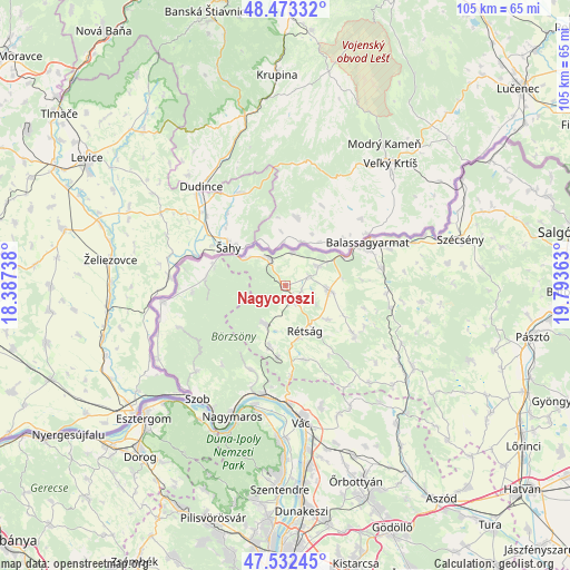
Nagyoroszi GPS coordinates[2]
48° 0' 18.108" North, 19° 5' 25.8" East
| Map corner | latitude | longitude |
|---|---|---|
| Upper-left | 48.47332°, | 18.38738° |
| Center: | 48.00503°, | 19.0905° |
| Lower-right: | 47.53245°, | 19.79363° |
| Map W x H: | 104.6×104.6 km | = 65×65mi |
| max Lat: | 48.46667° ⇑12.4% North |
| Nagyoroszi: | 48.00503° |
| min Lat: | ⇓87.6% South 45.79108° |
| min Long | Nagyoroszi | max Long |
| 16.27358° | 19.0905° | 22.68096° |
| W 39.9%⇐ | ⇒60.1% E |
Elevation
Elevation of Nagyoroszi is 196 m = 643 ft, and this is 66.3 m = 218 ft above average elevation for this country.
| Max E: |
444 m = 1457 ft | 8.5% |
| Nagyoroszi | 196 m 643 ft | |
| Avg. | 129.7 m = 426 ft | |
Min E: |
71 m = 233 ft | 91.5% |
See also: Hungary elevation on elevation.city.
Geographical zone
Nagyoroszi is located in North temperate zone (between Tropic of Cancer and the Arctic Circle). Distance of this North polar circle is 2063.5 km =1282.2 mi to North.| Distance of | km | miles | from Nagyoroszi |
|---|---|---|---|
| North Pole | 4669.4 | 2901.4 | to North |
| Arctic Circle | 2063.5 | 1282.2 | to North |
| Tropic Cancer | 2731.7 | 1697.4 | to South |
| Equator | 5337.7 | 3316.7 | to South |


Nearby cities:
15 places around Nagyoroszi: (largest is in red/bold)
• Balassagyarmat
17.1 km =10.6 mi,  63°
63°
• Bercel
27.9 km =17.3 mi,  122°
122°
• Diósjenő
8.1 km =5 mi,  205°
205°
• Dunabogdány
24.1 km =15 mi,  188°
188°
• Kismaros
19.7 km =12.2 mi,  198°
198°
• Kosd
22.9 km =14.2 mi,  163°
163°
• Nagymaros
25.5 km =15.8 mi, 202°
• Romhány
15.2 km =9.4 mi,  125°
125°
• Rétság
9.2 km =5.7 mi, 157°
• Szob
26.4 km =16.4 mi,  218°
218°
• Tolmács
8.5 km =5.3 mi,  170°
170°
• Verőce
20.5 km =12.7 mi, 191°
• Visegrád
26 km =16.2 mi, 200°
• Vác
25.7 km =16 mi, 172°
• Érsekvadkert
8.4 km =5.2 mi,  96°
96°
Sources, notices
• [Note1] Compared only with cities in Hungary existing in our database
• [Src1] Map data: © OpenStreetMap contributors (CC-BY-SA)
• [Src2] Other city data from geonames.org with taken over terms of usage.
• [Src3] Geographical zone / Annual Mean Temperature by Robert A. Rohde @ Wikipedia
