Kosd geodata
Kosd (Pest) is a populated place; located in Hungary in Europe/Budapest (GMT+2) time zone. With population of 2,371 people, there are 647 cities with bigger population in this country. Compared to other cities in Hungary, 78% of cities are located further ↓South; 57.3% of cities are located further →East and 79.8% of cities have lower elevation than Kosd. Note1


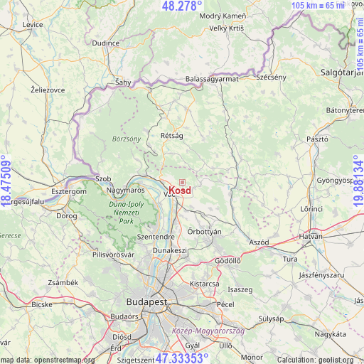
Kosd GPS coordinates[2]
47° 48' 28.476" North, 19° 10' 41.556" East
| Map corner | latitude | longitude |
|---|---|---|
| Upper-left | 48.278°, | 18.47509° |
| Center: | 47.80791°, | 19.17821° |
| Lower-right: | 47.33353°, | 19.88134° |
| Map W x H: | 105×105 km | = 65.2×65.2mi |
| max Lat: | 48.46667° ⇑22% North |
| Kosd: | 47.80791° |
| min Lat: | ⇓78% South 45.79108° |
| min Long | Kosd | max Long |
| 16.27358° | 19.17821° | 22.68096° |
| W 42.7%⇐ | ⇒57.3% E |
Elevation
Elevation of Kosd is 157 m = 515 ft, and this is 27.3 m = 90 ft above average elevation for this country.
| Max E: |
444 m = 1457 ft | 20.2% |
| Kosd | 157 m 515 ft | |
| Avg. | 129.7 m = 426 ft | |
Min E: |
71 m = 233 ft | 79.8% |
See also: Hungary elevation on elevation.city.
Geographical zone
Kosd is located in North temperate zone (between Tropic of Cancer and the Arctic Circle). Distance of this North polar circle is 2085.4 km =1295.8 mi to North.| Distance of | km | miles | from Kosd |
|---|---|---|---|
| North Pole | 4691.3 | 2915 | to North |
| Arctic Circle | 2085.4 | 1295.8 | to North |
| Tropic Cancer | 2709.8 | 1683.8 | to South |
| Equator | 5315.7 | 3303 | to South |


Nearby cities:
15 places around Kosd: (largest is in red/bold)
• Acsa
15.7 km =9.8 mi,  95°
95°
• Dunabogdány
10.4 km =6.5 mi,  259°
259°
• Göd
14.2 km =8.8 mi,  193°
193°
• Kismaros
13.4 km =8.3 mi,  284°
284°
• Leányfalu
12.2 km =7.6 mi,  214°
214°
• Romhány
14.4 km =8.9 mi,  24°
24°
• Rétság
13.7 km =8.5 mi,  347°
347°
• Sződ
9.3 km =5.8 mi,  183°
183°
• Sződliget
8.7 km =5.4 mi,  195°
195°
• Tahitótfalu
8.7 km =5.4 mi,  222°
222°
• Tolmács
14.5 km =9 mi,  339°
339°
• Verőce
10.9 km =6.8 mi, 279°
• Visegrád
15.7 km =9.8 mi, 260°
• Vác
4.7 km =2.9 mi, 221°
• Őrbottyán
15.5 km =9.6 mi,  149°
149°
Sources, notices
• [Note1] Compared only with cities in Hungary existing in our database
• [Src1] Map data: © OpenStreetMap contributors (CC-BY-SA)
• [Src2] Other city data from geonames.org with taken over terms of usage.
• [Src3] Geographical zone / Annual Mean Temperature by Robert A. Rohde @ Wikipedia
